This is part of a series of posts dedicated to the exploration of Swiss Alps Jungfrau-Aletsch-Bietschhorn, a UNESCO World Heritage site covering an entire area of 82,400 ha. The next few paragraphs will be about the site’s universal value (the reason why it is inscribed on the World Heritage list) and a brief introduction to various viewpoints, hiking trails and attractions in different regions in and around the inscribed area. If you have already read other posts related to the property, please click here to jump directly to the main content of this one.
As the UNESCO comments:
The extension of the natural World Heritage property of Jungfrau-Aletsch-Bietschhorn (first inscribed in 2001), expands the site to the east and west, bringing its surface area up to 82,400 ha., up from 53,900. The site provides an outstanding example of the formation of the High Alps, including the most glaciated part of the mountain range and the largest glacier in Eurasia. It features a wide diversity of ecosystems, including successional stages due particularly to the retreat of glaciers resulting from climate change. The site is of outstanding universal value both for its beauty and for the wealth of information it contains about the formation of mountains and glaciers, as well as ongoing climate change. It is also invaluable in terms of the ecological and biological processes it illustrates, notably through plant succession. Its impressive landscape has played an important role in European art, literature, mountaineering and alpine tourism.
自然世界遗产少女峰–阿雷奇冰河–毕奇霍恩峰(最早于2001年被列入)从东部扩展到西部,面积从53 900公顷扩展到82 400公顷。该遗址为阿尔卑斯高山——包括山脉最受冰河作用的部分和欧亚大陆山脉最大的冰川——的形成提供了一个杰出的实例。它以生态系统多样性为特点,包括特别受气候变化冰川融化而形成的演替阶段。该遗址因景色秀美、而且包含山脉和冰川形成以及正在发生的气候变化方面的丰富知识而具有突出的全球价值。在它尤其通过植物演替所阐释的生态和生物过程方面,该遗址的价值无法衡量。其令人难忘的景观在欧洲艺术、文化、登山和阿尔卑斯山旅游中起着重要作用。


In order to be inscribed on the UNESCO World Heritage list, sites must be of outstanding universal value and meet at least one of the ten Criteria for Selection. Swiss Alps Jungfrau-Aletsch-Bietschhorn meets
Criterion (vii): to contain superlative natural phenomena or areas of exceptional natural beauty and aesthetic importance, because the impressive landscape within the property has played an important role in European art, literature, mountaineering and alpine tourism. What’s the top 1 attraction in Switzerland? The Alps. What’s the most famous part of the Alps? The Jungfrau region. The area around Jungfrau, Aletschhorn and Bietschhorn, which includes the imposing north wall of the High Alps featuring Eiger, Mönch and Jungfrau and on the southern side many spectacular peaks and a valley system containing Europe’s largest glacier, is globally recognized as one of the most spectacular mountain regions to visit;
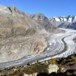
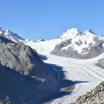
Criterion (viii): to be outstanding examples representing major stages of earth’s history, including the record of life, significant on-going geological processes in the development of landforms, or significant geomorphic or physiographic features, because the property provides an outstanding record of the geological processes that formed the High Alps and is abundant in diverse geomorphological features such as U-shaped glacial valleys, cirques, horns, valley glaciers and moraines. 20 – 40 million years ago, through uplifting and compressing, the formation of the High Alps began. Ranging from 809 m to 4,274 m high, the mountains in the property show 400-million-year-old crystalline rocks thrust over younger carbonate rocks due to the northward drift of the African tectonic plate. As the most glaciated part of the Alps, the site contains the largest and longest glacier in Europe – the Aletsch Glacier, which shows a range of classic glacial features. Furthermore, the glacier provides vital information about glacial history and ongoing processes, in particular related to climate change.
and Criterion (ix): to be outstanding examples representing significant on-going ecological and biological processes in the evolution and development of terrestrial, fresh water, coastal and marine ecosystems and communities of plants and animals, because within the property, diverse flora and fauna are represented in a range of habitats, and plant colonization in the wake of retreating glaciers provides an outstanding example of plant succession. Covering a wide range of altitudes and exposures (such as the dry southern side and wet northern side), the property includes diverse alpine and sub-alpine habitats. On the crystalline and carbonate rocks, a variety of ecosystems have evolved without significant human intervention. Particularly worth mentioning is the upper and lower tree-line of the Aletsch forest, a superb example of plant succession. The global phenomenon of climatic change, which is reflected in the varying retreating rates of the glaciers, is particularly well-illustrated in the region, providing new substrates for plant colonization.
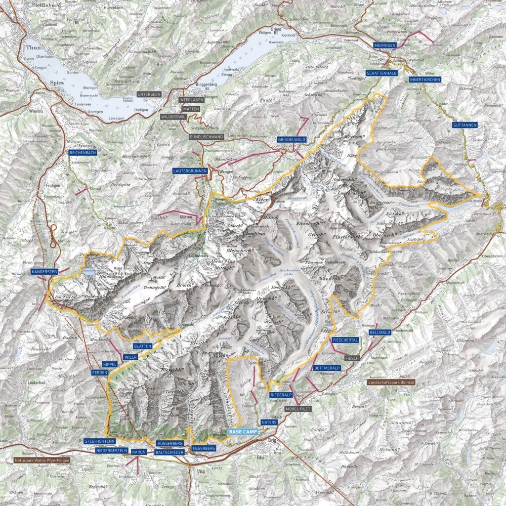
As you can see from the map above, the inscribed area is huge, so how can we explore it? Before giving you some suggestions based on my own experience and the information on www.jungfraualetsch.ch, let’s first learn some facts about the property:
- surface of the World Heritage area: 824 km2
- Population of the World Heritage region: 40,000 inhabitants
- 23 municipalities in the cantons of Valais (15) and Bern (8) are involved
- 9 mountains within the area are over 4000 meters and Finsteraarhorn is the highest peak (4274 m)
- around 50 mountains within the area are over 3500 meters
- the glaciers cover a total area of 350 km2
- the longest and largest glacier in the Alps, Aletsch Glacier (23 km) is located at the center of this protected area
- 88% of this area is without vegetation
- the Bernese Alps (Wetterhorn – Schreckhorn – Eiger – Mönch – Jungfrau – Gletscherhorn – Breithorn – Blüemlisalp) are considered one of the most famous mountain ranges in the world
As you might have noticed, most of the inscribed area is not accessible to normal tourists as it’s made up of either high mountains or glaciers. However, there are many viewpoints on the mountains around the property, most of which are conveniently connected to bus stops or train stations by cable cars. Personally, I strongly recommend the viewpoints within and around the Aletsch Arena, which provide amazing views of the Aletsch Glacier, Aletschhorn, Bietschhorn, Jungfrau, Mönch, Fiescherhorn and so on, and within the Jungfrau region including Grosse Scheidegg, First, Schynige Platte, Männlichen, Jungfraujoch, Schilthorn and so on, from which you can see clearly the northern wall of the High Alps featuring the signature Swiss skyline of Eiger, Mönch and Jungfrau. If you are a hiker, you have many more options and can get a closer look at the World Heritage site. Besides the numerous hiking trails in Jungfrau and Aletsch regions, I recommend you checking out the Lötschental Valley, Kandertal Valley (Gasterntal Valley and Lake Oeschinensee), and Rosenlauital Valley (Rosenlaui Glacier Gorge).
Exploring the regions I mentioned above will probably take you a very long time because they offer numerous viewpoints, hiking trails and attractions, and after that, I believe you will have a very good understanding of the universal value of the property such as its unparalleled beauty, exceptional record of the formation of the Alps, excellent demonstration of diverse geomorphological features and remarkable representation of on-going ecological and biological processes. If you are still not satisfied and want to have a completer experience, try visiting the municipalities of Raron, Eggerberg, Guttanen (Grimselwelt), Innertkirchen and Meiringen, where you will find more activities closely or remotely related to the World Heritage site. I read from the official website that there’s a long tour which allows you to hike around the property and discover and learn about it in 15 stages. The booklet providing relevant information regarding the routes and attractions is called «Key to the Alps», which is unfortunately only available in German. I think, even if you don’t speak German or plan to take the complete tour, the booklet should shed some light on the planning of your own expedition. Alternatively, there is a fold-out map available in English with overview and tips regarding highlights of the World Heritage site. I can send the digital version to you upon request and I’m sure it will also give you some inspiration.
- To find out the destinations and highlights recommended by jungfraualetsch.ch please click here.
- To find out the destinations and hiking tours recommended by myswissalps.ch please click here.
As I mentioned above, most of the inscribed area is not easily accessible to normal visitors and some parts of it are not clearly visible from the surrounding viewpoints. How can we gain deeper insights into this mysterious world then? Last but not least, don’t forget to visit the municipality of Naters, where the World Nature Forum Information and Visitor Center of the UNESCO World Heritage site Swiss Alps Jungfrau-Aletsch is located. In order to protect this extraordinary natural heritage and to promote sustainable development of this region, 23 municipalities within the cantons of Bern and Valais together with the Swiss Federation have agreed to work in collaboration. The World Nature Forum (WNF) is the base camp of this commission and its Information and Visitor Center provides us with necessary knowledge about this region and helps to raise our awareness of the importance of its protection. If it’s inconvenient for you to reach the area, you can also learn about it at home. On the official website, 19 thematic brochures (more in German) giving insights into the uniqueness, diversity and beauty of the region are available and can be downloaded as pdf. The thematic brochures are about agriculture and settlement, tourism and traffic, fauna and flora, water, culture, glacier, climate, and mountains while the regional brochures are about Oberhasli, Naters, Lötschental, “Suonen”, Raron – Niedergesteln, Grimselwelt, Kandertal, Grindelwald, Lauterbrunnen, Aletsch Region, and Bellwald.
I hope my introduction above gives you a general idea of why the Jungfrau-Aletsch-Bietschhorn region is so valuable and how to explore and learn about it. In a series of posts about the World Heritage site, I’ll focus on the hikes, viewpoints and tours I experienced and provide you with practical information, tips as well as detailed introduction to the geological and ecological processes, geomorphological features and ecosystems which are related to the property.
1. Intro: from Rosenlaui to Bachalpsee


Grosse Scheidegg and First are very popular destinations in the Jungfrau region and this time, I decided to explore both of them in one day. From the official website of the region, I learnt that there is a 5.9 km long panorama trail connecting the two places and it fits in my plan perfectly. Now, I’ll show you the itinerary of my day trip: Zurich HB – [train] > Meiringen – [PostBus service] > Grosse Scheidegg – [hike] > First – [hike] > Bachalpsee – [hike] > First – [cable car] > Grindelwald – [train] > Zurich HB.
The views from Grosse Scheidegg, First and the panorama trail were amazing but what surprised me was the bus ride from Meiringen to Grosse Scheidegg via Rosenlaui and Schwarzwaldalp, which was like a guided tour, and the hike from First to Bachalpsee, which allowed me to see Jungfrau from a better angle and led me to a beautiful mountain lake with crystal clear water. In the next chapters, I’ll give you a detailed introduction to the PostBus ride, the Mountain Panorama Trail: Grosse Scheidegg – First, First viewpoint and the thrilling Cliff Walk, and the hike between First and Bachalpsee.
2. PostBus service: Rosenlaui Route


When I was looking for hiking trails in and around the UNESCO World Heritage site Swiss Alps Jungfrau-Aletsch-Bietschhorn, I came across the Rosenlaui Valley, which lies at the foot of Engelhörner, Dossen, Wellhorn and Wetterhorn. What I didn’t expect was I crossed it by accident by bus on my way to Grosse Scheidegg. Please note, this is not a normal bus service but a PostBus excursion featuring the Rosenlaui Route (Meiringen–Schwarzwaldalp–Grindelwald), on which the driver gives introductions to the valley, surrounding mountains and nearby attractions. If you understand German, it feels like a guided tour. Considering it’s a special service, GA or Tageskarte is not valid for the entire route (only until Schwarzwaldalp if I remember correctly), but don’t worry, depending on where you want to go, you just need to pay the extra fare. For information about the bus schedule and ticket prices please click here.
If you are a fan of Sherlock Holmes, do not miss the departure point of the excursion – Meiringen, where the Sherlock Holmes Museum is located. It was opened on 4th May 1991 (100th anniversary of the death of Sherlock Holmes) in the presence of the Sherlock Holmes Society of London and Dame Jean Conan Doyle, the second daughter of Sir Arthur Conan Doyle, and exhibits objects which belonged to Sir Conan Doyle and are related to the detective fiction – “Stories of Sherlock Holmes”. Not far from Meiringen train station, you can take the Reichenbachfallbahn to go up to the Reichenbach Falls, where the fictional detective fights to the death with Professor Moriarty at the end of “The Final Problem”.
In the 18th century, when artists and scientists discovered the Alps as a tourist destination, the crossing of Grosse Scheidegg was the highlight of almost every Swiss trip. On 12th October 1779, Johann Wolfgang von Goethe went from Grindelwald to Grosse Scheidegg and then via Schwarzwaldalp and Rosenlaui to the Haslital Valley. At the end of his journey he wrote: “No thought, description or memory reaches the beauty or size of the objects.” (“Kein Gedanke, keine Beschreibung noch Erinnerung reicht an die Schönheit und Grösse der Gegenstände.”) The bus followed the footsteps of Goethe and when it was going through the Rosenlaui Valley, I heard the driver introducing the Rosenlaui Glacier Gorge, a natural jewel located inside the World Heritage site. It is open from the end of May to the end of October and inside, there’s a path taking visitors to pass along waterfalls, natural whirlpools and rocks of peculiar shapes. By witnessing and hearing the glacial water roaring through narrow rock passages and mystical grottos, no one will ever doubt the power of nature and its talent in sculpting.
After stopping at Schwarzwaldalp, where you can get off and visit an old water-powered sawmill, the bus went directly to Grosse Scheidegg, where I started my hike. It was interesting to have an excursion through the Rosenlaui Valley but for me, the valley is too important to be visited by bus. The good thing is the introduction of the driver gave me some inspiration and in the next summer, I’ll certainly return to explore this area again, but this time, on foot. My plan is to hike from Rosenlaui to Grosse Scheidegg and on the way, I’ll make sure to visit the glacier gorge and the ancient sawmill.
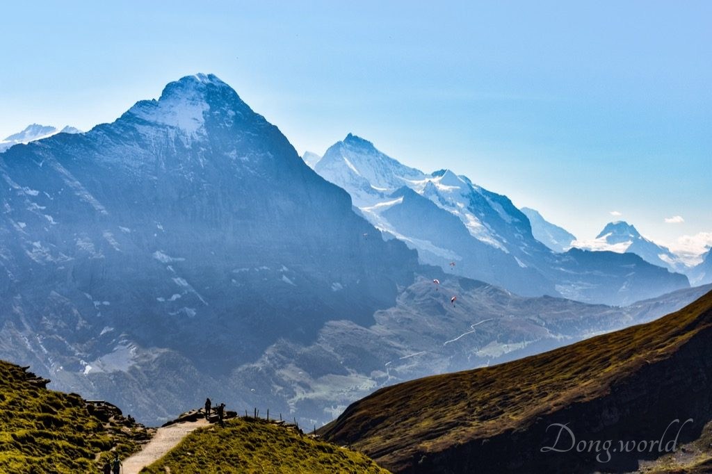
2. Mountain Panorama Trail: Grosse Scheidegg – First


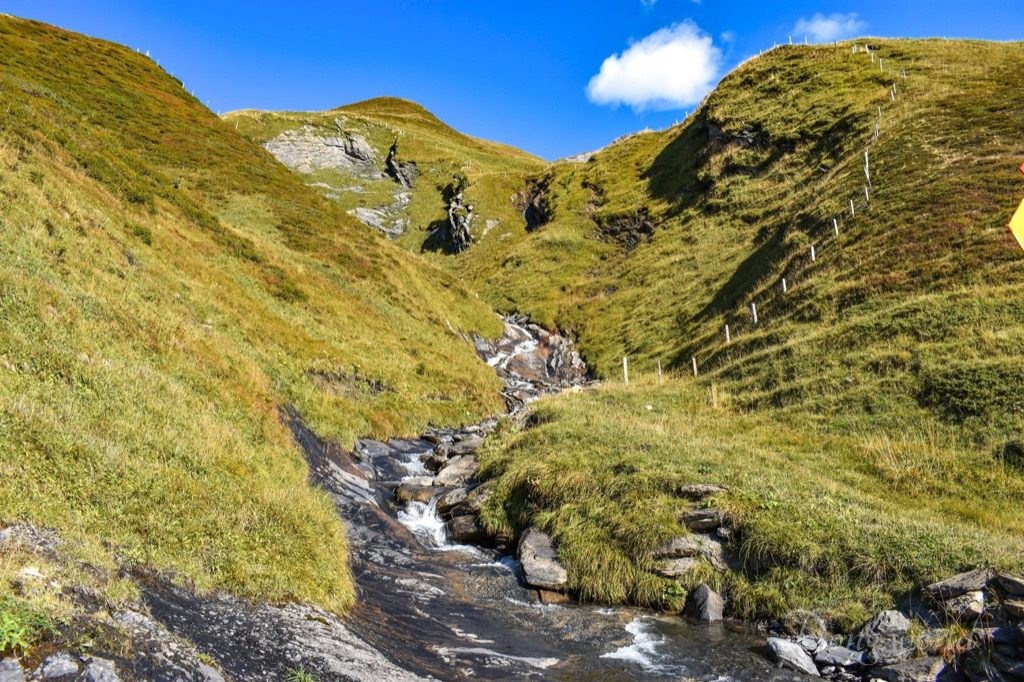
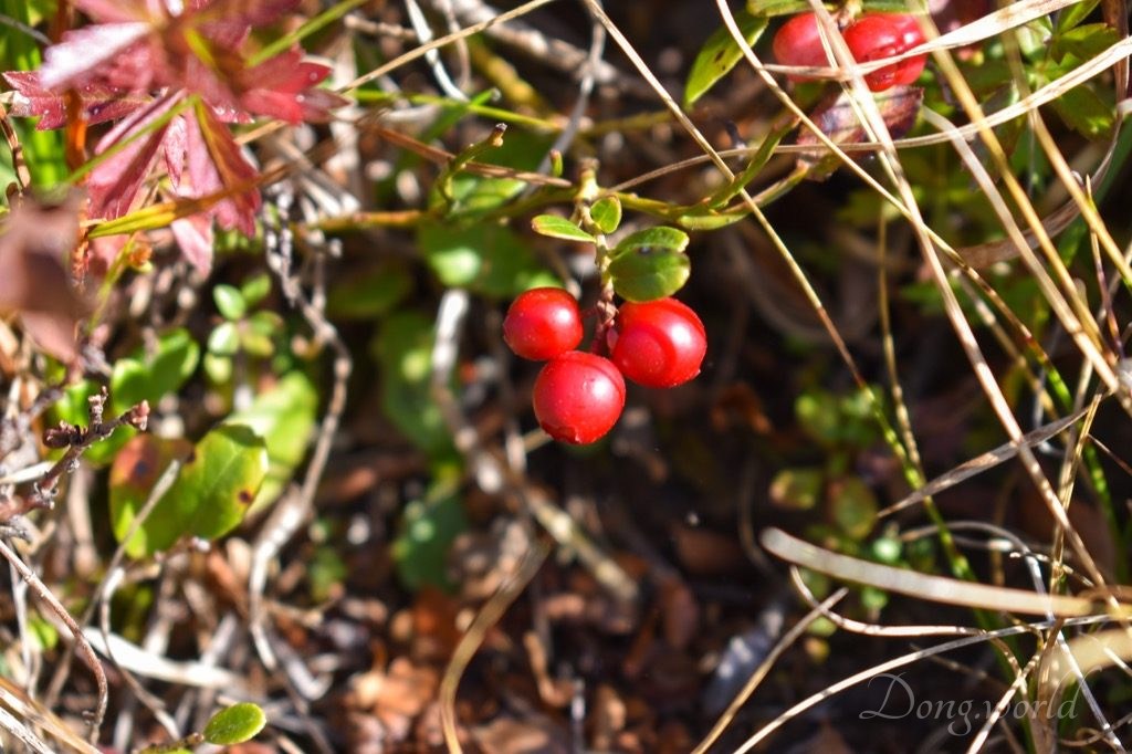

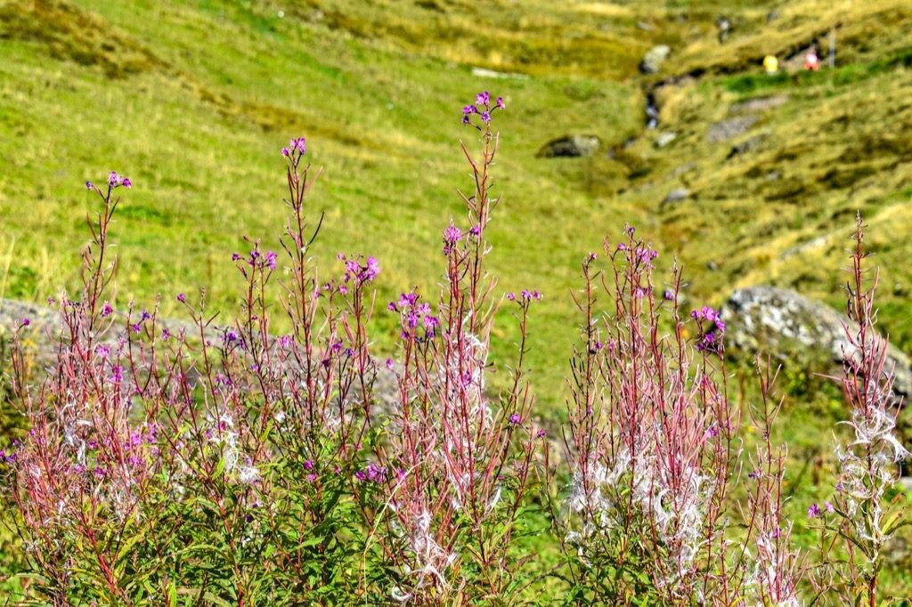
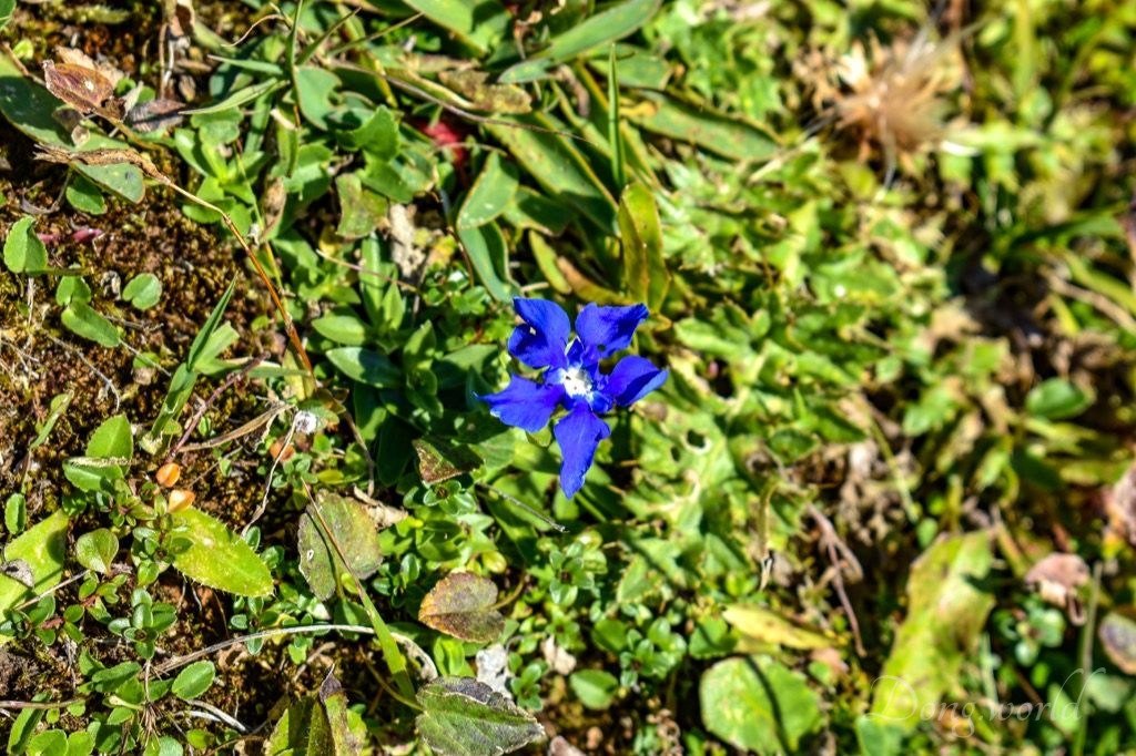
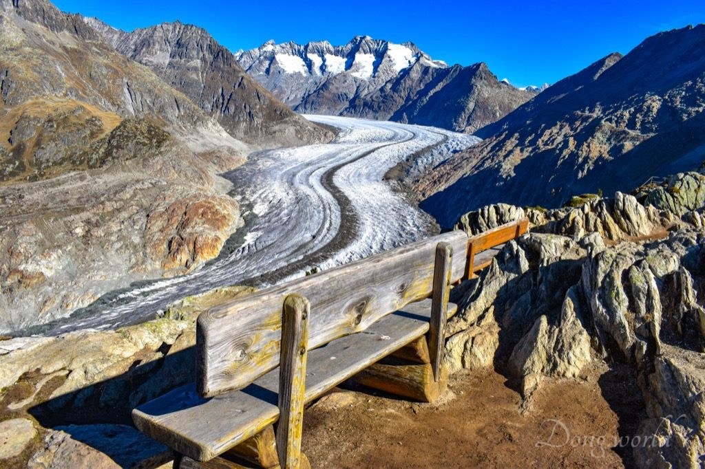
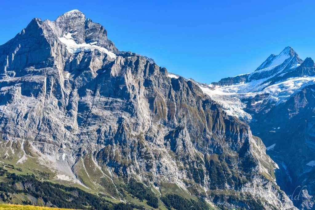
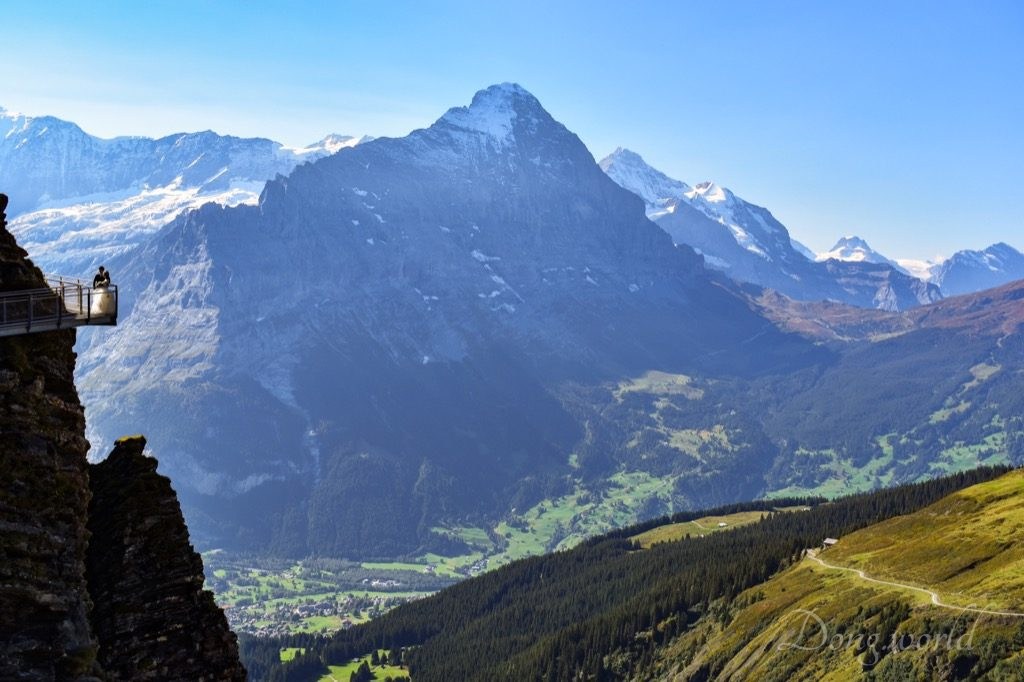
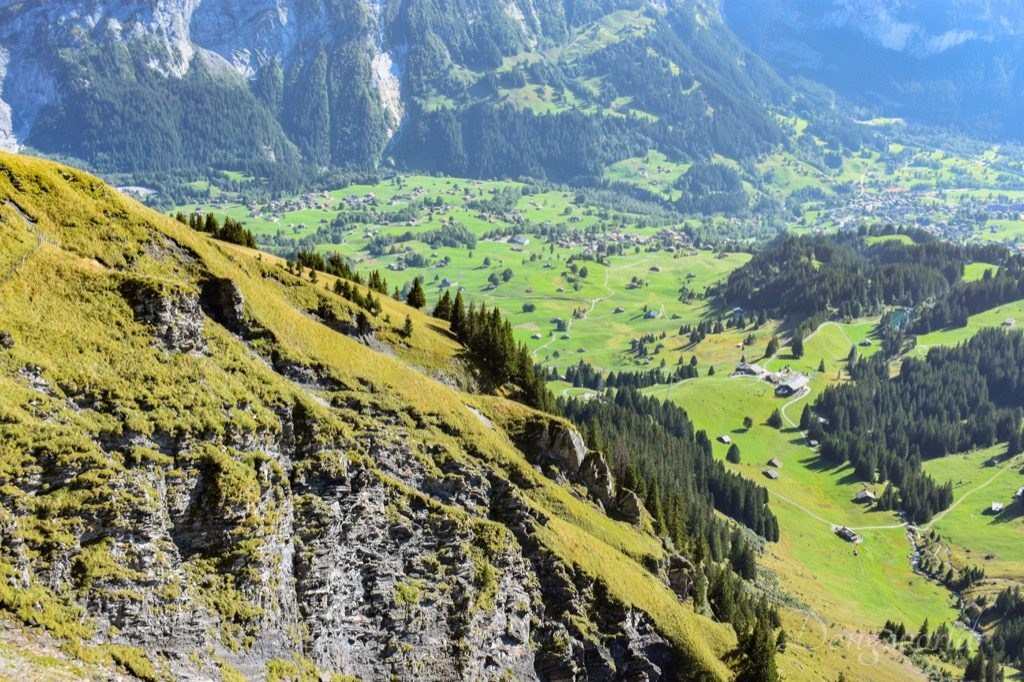
As part of the Alpine Pass Route, a long-distance hiking trail through the Alps in Switzerland which starts in Sargans in eastern Switzerland, and crosses the heart of the country westwards to finish in Montreux on the shore of Lake Geneva, the Grosse Scheidegg is a mountain pass crossing the col between Schwarzhorn (2928 m) and Wetterhorn (3692 m). Prior to the coming of the railways and the introduction of tourism to the area, it provided access for local livestock and dairy farmers to the important export route to Italy over the Grimsel Pass. With the coming of the railways, the importance of the pass as a trade route disappeared. At its summit, there’s a restaurant and hotel, where the PostBus stopped and I started my hike. On the way, I could see the cable car station of First almost all the time and I always felt I could reach it easily within the next half an hour. After an hour, I stopped dreaming and at the end, it took me almost two hours to reach the destination. Thanks to the amazing view of the High Alps including Wellhorn (3191 m), Wetterhorn (3692 m), Oberer Grindelwaldgletscher, Schreckhorn (4078 m), Finsteraarhorn (4273 m), Gross Fiescherhorn (4048 m), Unterer Grindelwaldgletscher, Fieschergletscher, Eiger (3970 m), Mönch (4107 m) and Jungfrau (4158 m), my eyes were never tired or bored. Besides gazing at the striking mountains, don’t forget to pay attention to the modest features along the way such as the moor with shiny puddles, the merry mountain streams, the rocks of interesting shapes, the unnoticeable but adorable wild flowers and one of the representatives of the Alps – the Swiss cows. The 1st picture above is probably the best shot of the hike. What image is more Swiss than a Swiss cow wearing a bell around its neck at the background of the distinct Eiger and Mönch?
Now, I’ll give you some tips for the panorama hike based on my own experience.
- The distance of the hike is 5.9 km and it takes around 2 hours to finish;
- the ascent is 275 m and the descent is 73 m;
- the difficulty level of the hike is easy;
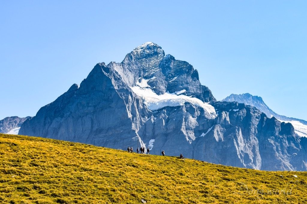
- highlight on the way is the unobstructed view of the High Alps and glaciers including Wetterhorn (3692 m), Oberer Grindelwaldgletscher, Schreckhorn (4078 m), Finsteraarhorn (4273 m), Gross Fiescherhorn (4048 m), Unterer Grindelwaldgletscher, Fieschergletscher, Eiger (3970 m), Mönch (4107 m) and Jungfrau (4158 m). Please note, Jungfrau can only be seen when you are close to First because when you are close to Grosse Scheidegg, it’s blocked by Eiger, and Mönch can only be seen when you are close to Grosse Scheidegg because when you are close to First, it’s blocked by Eiger.
- though the trail can be managed with normal sports shoes, hiking shoes are recommended. There are a few short sections which are narrow, close to rather steep slopes and a bit slippery due to dust. Just be careful when you pass them;
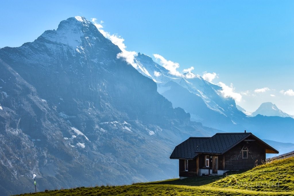
- at the summit of Grosse Scheidegg, there’s a restaurant and hotel and at First cable car station, there’s a restaurant and hotel called Berggasthaus First;
- several benches on the way facing the High Alps are ideal places for recharging yourself. Remember to take some snacks and enough water with you;
- I took the trail on 20th September 2018, when the temperature was a bit low in the mountains. I was wearing a thin winter jacket and long pants when I arrived at Grosse Scheidegg and after half an hour of walking, I changed to t-shirt and shorts because of the sun and exercise;
- sun cream is a must for a sunny day and don’t forget to protect the back of your neck as well;
- close to First, you can choose between a mountain biking road, which is comparatively longer but gentler, and a hiking path, which is shorter but steeper, to reach the destination.
Marmot Trail and Barbecue Area

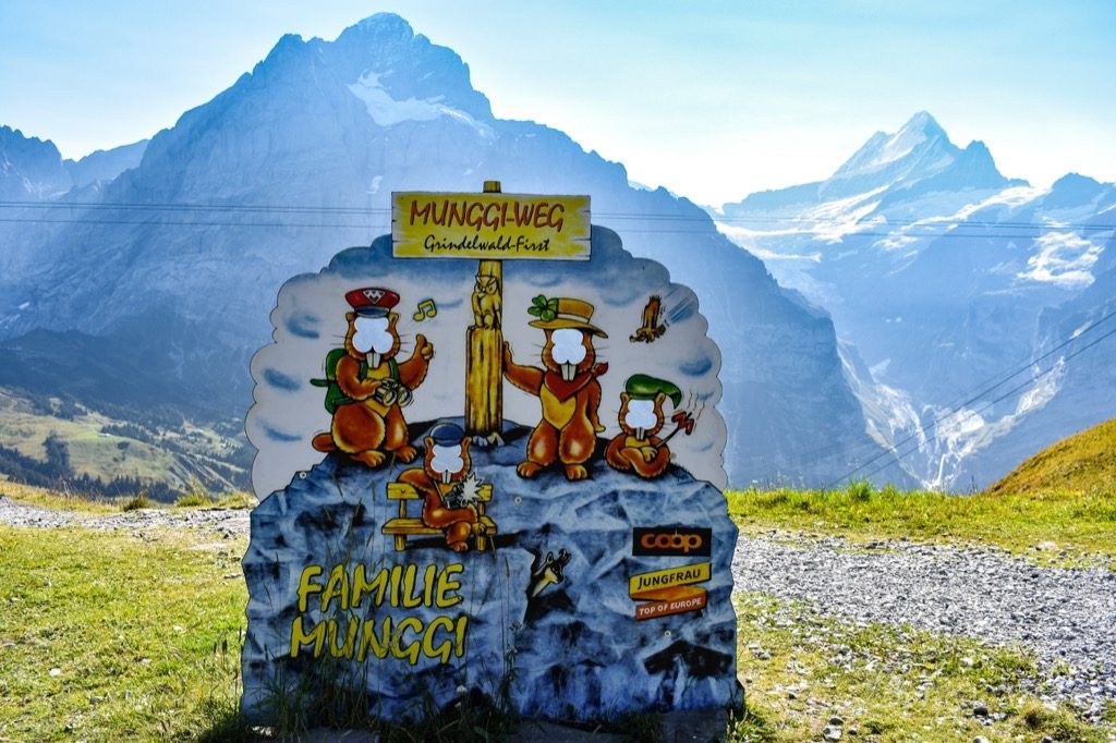

On the Mountain Panorama Trail, I passed a barbecue area, which happens to be the end of the Marmot Trail of First. It starts at First cable car station, which is marked by Info Board A and a photo wall, and after going through 6 more info boards, stops at Info Board H, which is around 30 mins away from the summit of Grosse Scheidegg. It is an easy trail designed for the curious minds who want to learn about the life of marmots and the info boards along the way will explain how they live up in the mountains, who their friends and enemies are and what they eat. If you are interested, take a Munggi Book from any of the cable car stations on the Grindelwald – First cableway and write down the keys to the questions on the info boards. At the end of your trip, hand in the competition coupon to the station at Schreckfeld, Bort, or Grindelwald and receive a gift as a souvenir. At the barbecue area, the grill and wood are provided but don’t forget to bring your own food, lighter, etc. Please note, this is not a circular trail so at its end, you need to either walk further to the summit of Grosse Scheidegg and then take the PostBus to Meiringen or Grindelwald, or walk back to First or Schreckfeld and then take the cable car down to Grindelwald. Whichever way you take, plan your trip in advance and don’t miss the last bus or cable car going down.
3. Grindelwald – First: Top of Adventure
No wonder First is one of the top three destinations in the Jungfrau region. Its views of the High Alps and valley and leisure/adventure facilities are indeed impressive. Though I chose to hike from Grosse Scheidegg to First, you can reach it conveniently from Grindelwald by cable car. In this way, you can simply have a fun day without feeling sweaty or tired.
- For information about the schedule and ticket prices of Grindelwald – First cableway please click here.
Now, I’ll introduce how you can enjoy and maybe challenge yourself a little bit here.
3.1 The view


First is famous for its view of the High Alps and their glaciers including Wellhorn (3191 m), Scheidegg Wetterhorn (3361 m), Wetterhorn (3692 m), Oberer Grindelwaldgletscher, Lauteraarhorn (4042 m), Schreckhorn (4078 m), Finsteraarhorn (4273 m), Hinter Fiescherhorn (4025 m), Gross Fiescherhorn (4048 m), Unterer Grindelwaldgletscher, Fieschergletscher, Eiger (3970 m), and Jungfrau (4158 m), Tschingelhorn (3562 m), Blüemlisalphorn (3657 m), Wilde Frau (3259 m), and Schilthorn (2970 m). If you come here on a sunny day, which is recommended for optimal viewing, don’t forget to take your sunglasses and if possible, binoculars. For photographers, the direction of the sun isn’t ideal for photo shooting of the giant peaks in the middle of the day, but early in the morning or late in the afternoon, the lighting is better.
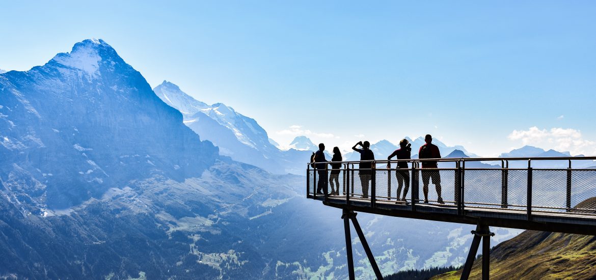
To have a good view of the Alps, I suggest you have a walk around the cable car station, take a rest on the terrace of Berggasthaus First where an info board helping you recognize the mountain peaks is located, and challenge yourself on the Cliff Walk, in particular the viewing platform at its end with a glass floor. If you want to see how the Cliff Walk path encircles the minor summit like a snake, I suggest you walk up the small hill behind the restaurant or even better, walk for around 10 mins in the direction of Bachalpsee. On my way down from First to Grindelwald, I shot the 7th picture above from the inside of the cable car and I regard it as one of the best shots of the entire trip.
3.2 Leisure/adventure facilities
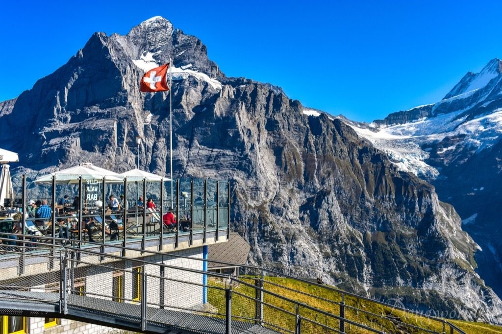

Besides being an amazing viewpoint of the UNESCO World Heritage site Swiss Alps Jungfrau-Aletsch-Bietschhorn, First features a lot of leisure and entertaining facilities, which give it the nickname “Top of Adventure“. I had lunch in the restaurant which was decent, but if you don’t want to have a normal meal here, just sit on the terrace in front of the magnificent Wetterhorn and have a cup of coffee or a glass of beer. I assure you it will be an unforgettable experience. If you want to familiarize yourself with the mountain peaks, the info board on the terrace will tell you their names.
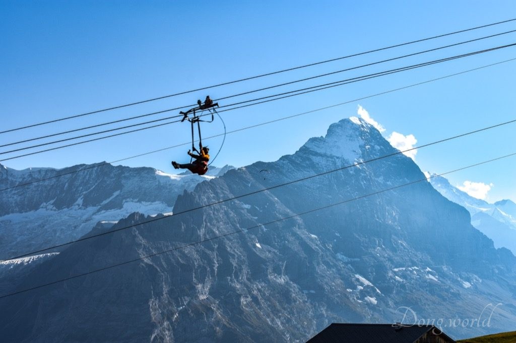
Close to the cable car station, there’s another station where the First Glider (minimum age: 10 years. minimum height: 130 cm. maximum body weight: 125 kg) and First Flyer (body weight: between 35 and 125 kg) take off. First Glider takes its four passengers to float through the mountain landscape and enjoy a panoramic view at high speeds. To begin with, it is pulled backwards from Schreckfeld to First at the speed of 72 km/h and on the way back passengers will glide the 800-meter-long flight route at the speed of up to 83 km/h. With First Flyer, up to four people whiz along the 800-meter-long steel cable from First to Schreckfeld at a top speed of 84 km/h. In some places, they hover approximately 50 meters above the alpine meadows. For information about the prices of the rides please click here.
As I read from the official website, some other exciting activities are also available from First. For example, the 15 x 15 meter big and 3.5 meter thick air cushion called Bagjump awaits jumpers landing from varying heights; the First Mountain Cart takes riders down the mountain on almost any terrain and is safe, comfortable and also suitable for children higher than 135 cm; and the Trottibike Scooter allows riders to stand upright on a wide footboard and roll along pleasantly downhill even on bumpy surfaces. Please note, the activities mentioned in this paragraph are only available in the summer season and for information about their prices, please click the links attached to them respectively.
Having mentioned so many attractions at First, the most popular one is yet to be introduced.
Cliff Walk


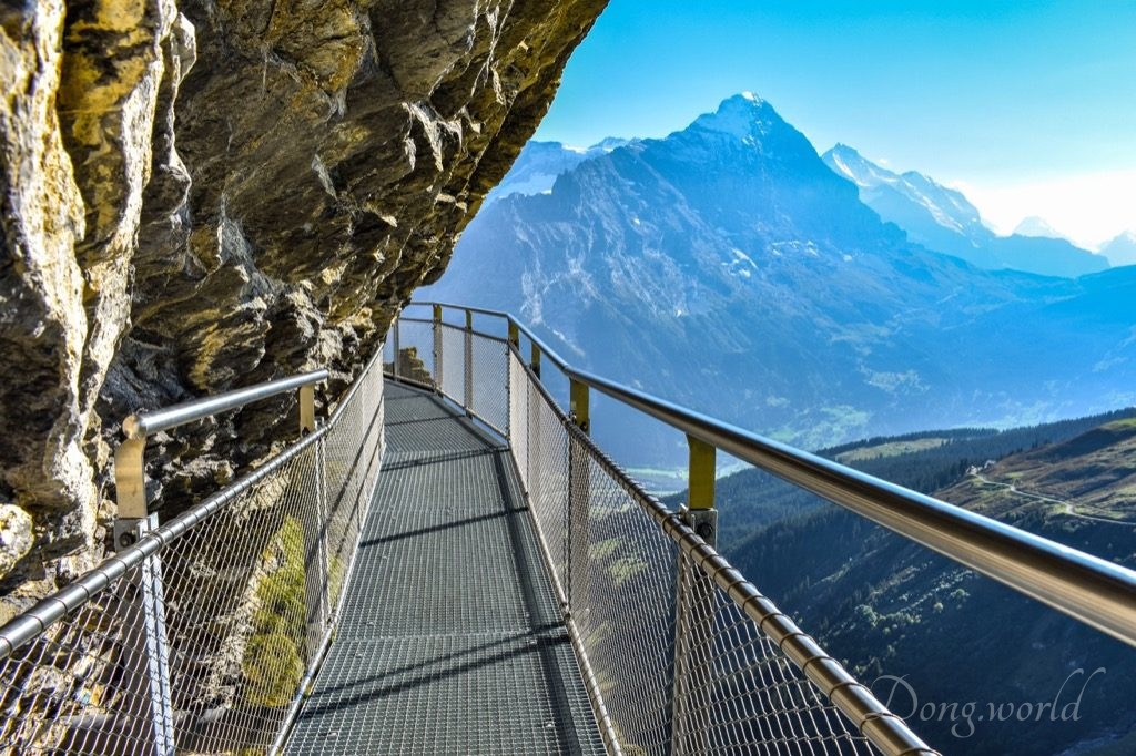
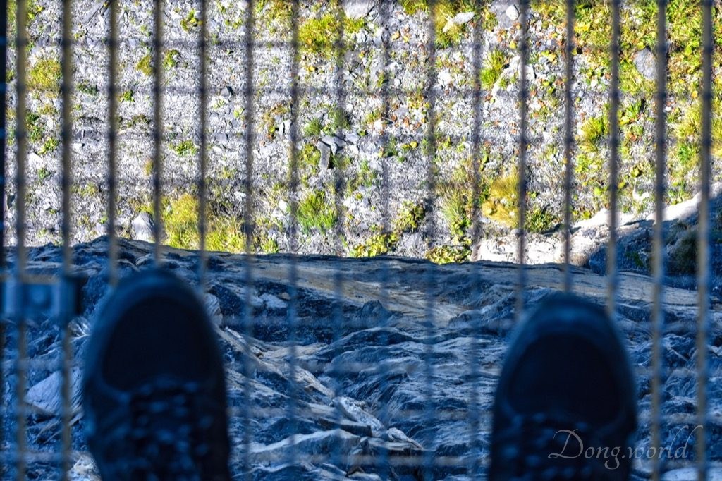
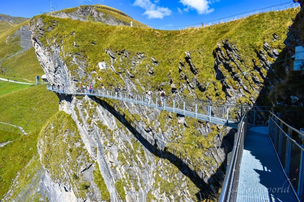
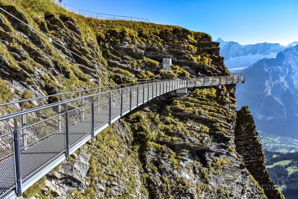
The Cliff Walk by Tissot is the most popular attraction on First and can be visited free of charge. Essentially, it’s a pathway off the ground which brings thrill to visitors, in particular those who are with acrophobia (fear of heights). In general, there were three sections which made me nervous and a bit scared. The first one was the viewing platform at the end of the trail (as you can see in the 2nd picture above), whose floor was made of glass and through it, I could see the pasture 45 meters below. Supported by steel substructures, the end section provided an unobstructed view of the mountains, glaciers, pasture, forest and valley. The second one was the part attached to the sheer rock face. Considering the path was paved with metal grids, it’s difficult to keep walking without noticing how high and steep the cliff was. The third one was the suspension bridge, which was hung below suspension cables. This was in my opinion the most unstable section of the trail because it was only fixed at both ends and by cables and while crossing, I felt it swinging. Fortunately, during my visit, there weren’t many people and I could walk on the trail at my own pace. Please follow the sign to start the walk from the actual entrance because otherwise, on a busy day, you might easily get stuck in a crowd coming from both directions. The walk is thrilling for most people but if you have serious acrophobia, I’m not sure if you should take the challenge. Anyway, the choice is yours and all I can say is I believe the trail is secure.
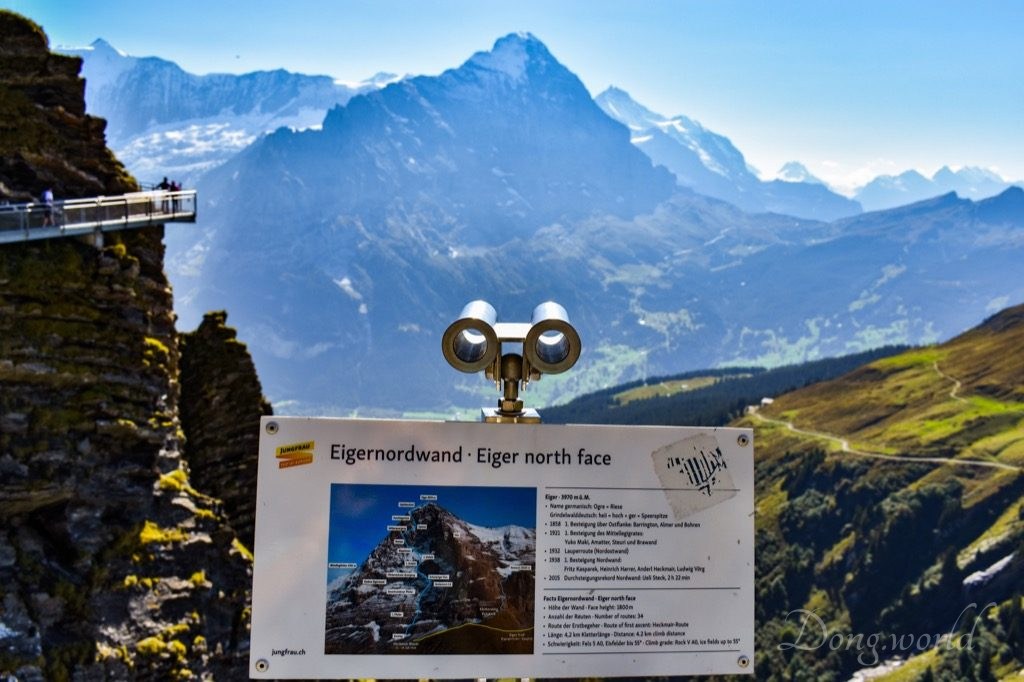

On the trail, there were three info boards introducing the Eiger north face, the Bachläger Waterfall and the Bachalp Lake moorland, which gave the walk an educational touch.
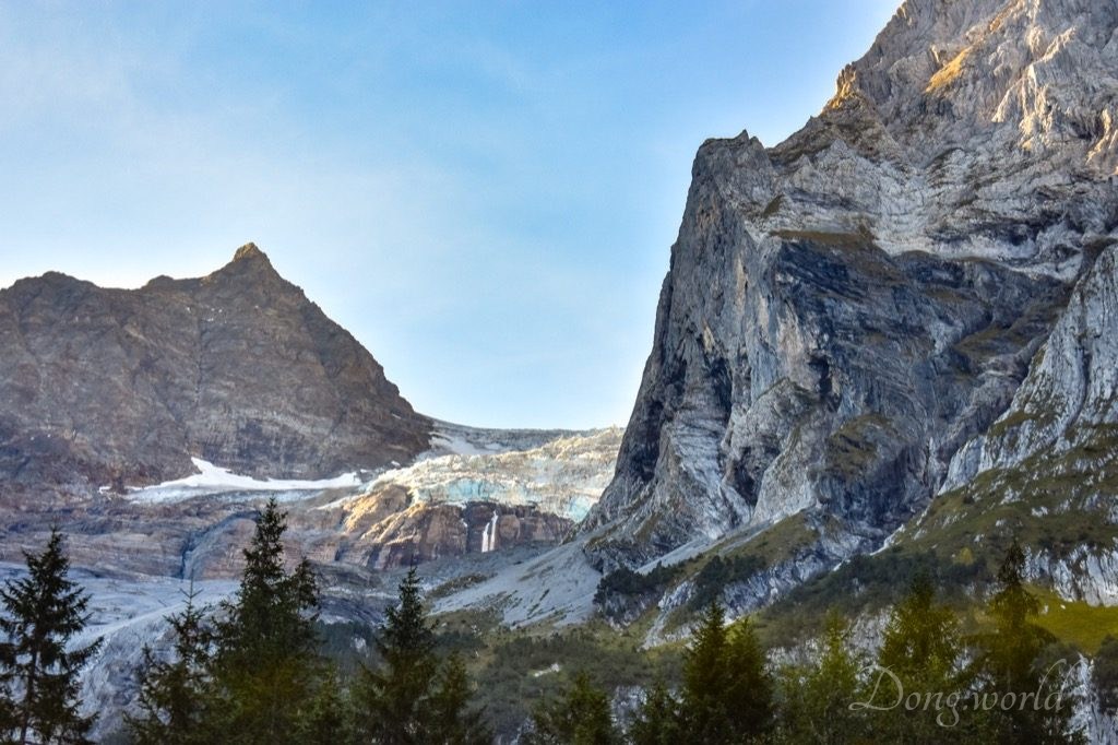
As part of the world-famous trio – Eiger, Mönch and Jungfrau, Eiger, in particular its 1,800-meter-high north face of rock and ice, which is also the biggest north face in the Alps, is clearly visible from here. The first ascent of Eiger was made by Swiss guides Christian Almer and Peter Bohren [de] and Irishman Charles Barrington, who climbed the west flank on August 11, 1858. Considered amongst the most challenging and dangerous ascents, the north face was first climbed through the “Heckmair Route” in 1938 by an Austrian-German expedition. Before their success, most of the attempts ended tragically, for which Eiger was highly publicized. Since 1935, at least sixty-four climbers have died attempting the north face, earning it the German nickname Mordwand, which means “murder(ous) wall“. Although the summit of the Eiger can only be reached by experienced climbers, a railway tunnel runs inside the mountain, and two internal stations provide easy access to viewing windows carved into the rock faces. They are both part of the Jungfrau Railway, which runs from Kleine Scheidegg to Jungfraujoch, the highest railway station in Europe. The two stations within Eiger are Eigerwand (behind the north face) and Eismeer (behind the south face), at around 3,000 meters asl. Since 2016 the Eigerwand station is not regularly served anymore. I’m quite sure I will never have the courage or ability to climb the north face but if you are interested, the face hight is 1800 m and on it, there are 34 different routes.
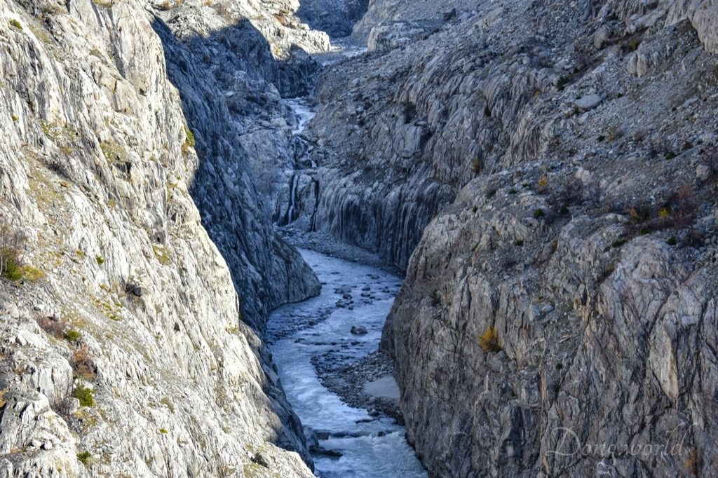
The Bachläger Waterfall (as you can see in the 2nd picture above) is one of the largest waterfalls in Switzerland. The Milibach Creek divides naturally in Bachläger in a southwestern and a northwestern watercourse and falls in the rare case of a parallel on the rock face. The creek begins at Bachalpsee (2265 m asl.) and flows through a large moor landscape which is of national importance. In Grindelwald, the Milibach merges with Lütschine, which flows into Lake Brienz and from there, the water flows as the Aare river via Lake Thun and Lake Biel into the Rhine near Koblenz, which finally flows into the North Sea near Rotterdam. The history of the Bachalpsee Moor is similar to that of other moorlands. The retreat of the Bachalp Glacier between Faulhorn and Schwarzhorn left behind a landscape with hollows, moraines and bare soils. Water accumulated in the sealed valleys, which gradually silted up, and plantations of the ice-free regions migrated, creating a landscape with extensive bogs. During the 7th millennium BC, an interglacial period, pine trees, spruces, as well as green alder trees spread to more than 2000 m asl., but when it got colder, the trees disappeared. The forest retreated to the current tree-line and in Bachläger, it was cleared for pasture. Up until the Middle Ages, moors were avoided by humans because they were thought to be inhabited by witches and spirits. Criminals were thrown into moor pools and human sacrifices were made to appease the angry spirits.
I hope you’re not afraid of moors because now we will go through one to trace the origin of the Bachläger Waterfall.
4. From First to Bachalpsee
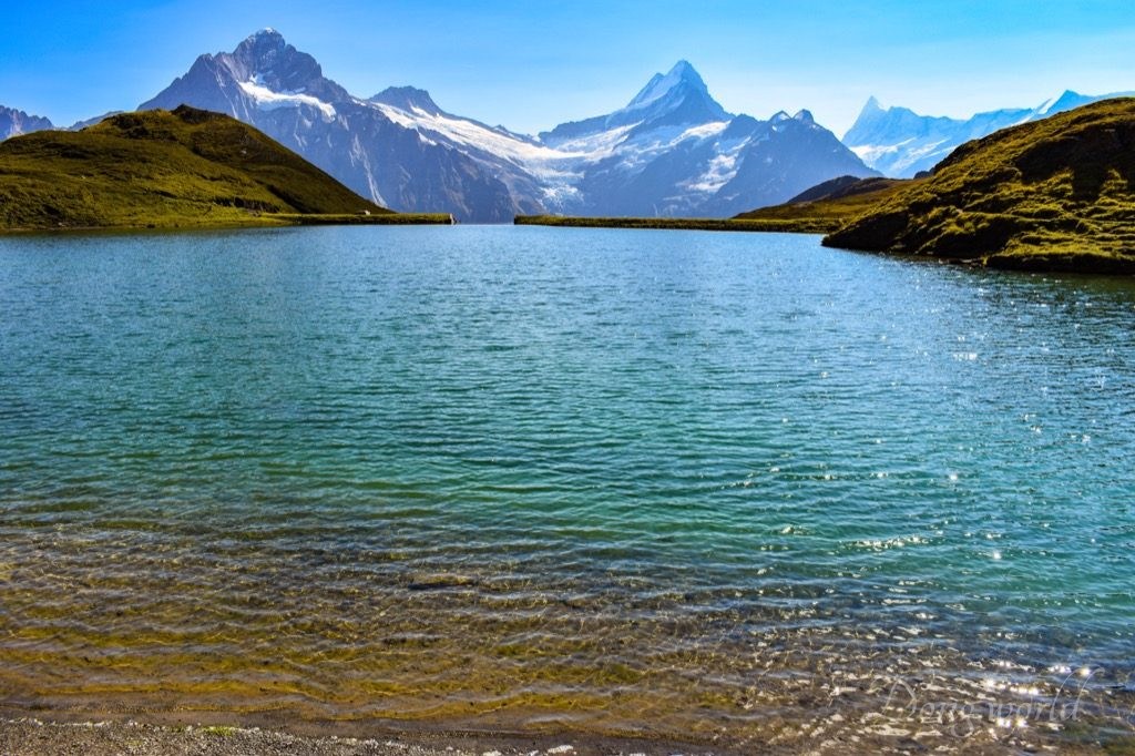
4.1 Bachalpsee

Bachalpsee is a lake with an area of 8.06 ha in the Bernese Oberland. Located at an elevation of 2,265 m, it is split by a natural dam, with the smaller part being 6 m lower. As I read from Wikipedia, the lake was featured in Gmail as part of its mountain theme background. According to my experience, the area around the lake is an ideal place for picnic. If you’ve already had lunch, just sit on the grass, breathe freely the fresh mountain air and enjoy the unparalleled view of Bachalpsee and at its background, Wetterhorn (3692 m), Oberer Grindelwaldgletscher, Schreckhorn (4078 m) and Finsteraarhorn (4273 m). If the slopes are crowded when you first reach the lake, just walk a bit further along the shore and soon you will find an empty space and peaceful moment of your own. I visited the lake in September 2018 and the water was really cold for me. Nevertheless, I still saw people swimming and at the same time screaming in it. I guess it must be a popular refreshing spot for hikers in the summer. Take a close look at the 3rd picture above, can you guess what on top of the hill was? That was an alphorn player playing the alphorn, a musical instrument used by mountain dwellers in the Swiss Alps, Austrian Alps, Bavarian Alps in Germany, French Alps, etc. I could hear the music all the time when I was by the lake but it took me quite some time to spot the player. More interestingly, I remember meeting him on the way.
4.2 From First to Bachalpsee

Lake Bachalp is not right next to the First mountain station so in order to reach it, you need to hike for around an hour. However, the trail is very easy and I believe almost everyone can make it without much effort. Now I’ll give you some tips for the leisurely walk.
- It takes about an hour to reach the lake and another hour to go back to First cable car station;
- the hike is very easy and can be easily managed with sports shoes;
- the trail is open in the summer season and winter season but not in-between. For example, in 2018 and 2019, it’s open from June to October and from the end of November to the end of March;
- just follow the main road and you won’t get lost;
- highlights on the way are the panoramic view of the High Alps, glaciers, pasture, forest and valley, the moor landscape, and of course the lower and upper Lake Bachalp;
- when you are on the trail and close to First, you can see and take a nice photo of how the Cliff Walk encircles the minor summit. When you are close to the lake, you get a slightly better view of Jungfrau (than from First);
- I hiked on a sunny day (26th September 2018) and the temperature was pleasant. On the way, because there wasn’t much exercise, I was wearing a thin winter jacket and long pants;
- sun cream is a must for a sunny day;
- at First, there’s a Berggasthaus (Mountain Guest House) providing accommodation and normal meals. I suggest that you take some snacks and enough water with you and have a picnic or snack break next to the lake.
5. Grindelwald

The cable car brought me down from First to Grindelwald conveniently, where I started my journey back to Zürich. I guess the name Grindelwald shouldn’t sound strange to you as there’s a character named Gellert Grindelwald in the Harry Potter movies who, before Lord Voldemort, caused hell in the Wizarding World. In 1945, he was finally defeated by his former childhood friend, Albus Dumbledore. In reality, Grindelwald is the name of a peaceful village in Switzerland’s Bernese Alps, a popular gateway to the Jungfrau region, which is paradise for skiers in winter and hikers in summer. It’s also a base for mountain-climbing ascents up the iconic north face of Eiger.
As I mentioned at the beginning of the post, the UNESCO World Heritage site Swiss Alps Jungfrau-Aletsch-Bietschhorn covers a huge area (82,400 ha.) and can be admired from numerous viewpoints and explored through many hiking trails and tours. In this post, I focused on the PostBus excursion – Rosenlaui Route, which goes from the Haslital Valley to Grindelwald via Rosenlaui, Schwarzwaldalp and Grosse Scheidegg; the panoramic hike from Grosse Scheidegg to Grindelwald – First; the viewpoints and adventures at First; and the hike from First to Lake Bachalp. Throughout the day trip, I was accompanied by the magnificent High Alps and glaciers including Wellhorn (3191 m), Scheidegg Wetterhorn (3361 m), Wetterhorn (3692 m), Oberer Grindelwaldgletscher, Lauteraarhorn (4042 m), Schreckhorn (4078 m), Finsteraarhorn (4273 m), Hinter Fiescherhorn (4025 m), Gross Fiescherhorn (4048 m), Unterer Grindelwaldgletscher, Fieschergletscher, Eiger (3970 m), Mönch (4107 m) and Jungfrau (4158 m), Tschingelhorn (3562 m), Blüemlisalphorn (3657 m) and Wilde Frau (3259 m), all of which are inside the World Heritage site. In the future, I’ll keep discovering interesting and impressive viewpoints and hiking trails in and around the property, and I’ll make sure to keep you updated. To be continued…