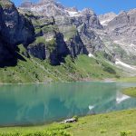
A mountain pass is a navigable route through a mountain range or over a ridge. Since many of the world’s mountain ranges have presented formidable barriers to travel, passes have played a key role in trade, war, and both human and animal migration throughout earth’s history. This time, invited by my friend, I had the opportunity to experience one of the passes in Switzerland one day before it closed. In my imagination, mountain passes were always winding, narrow and steep but the Klausenpass changed my opinion. As a two-lane road, it was indeed winding but not narrow or steep. Even buses can drive on it, let alone cars. However, still be careful and slow if you are not used to driving on mountain roads. In this post, I’ll first introduce to you the Klausenpass and then I’ll focus on my hike to the Griesslisee, a lovely blue lake under the feet of Mountain Clariden and fed by the Clariden Glacier.
1. Klausenpass


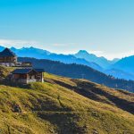
Klausen Pass (German: Klausenpass) is a high mountain pass in the Swiss Alps connecting Altdorf in the canton of Uri with Linthal in the canton of Glarus. It is crossed by a paved road, which, between Altdorf and Linthal, is 46 kilometers long. The road approaches the summit from Altdorf via the Schächen Valley communities of Bürglen, Spiringen and Unterschächen, and descends to Linthal via the Urnerboden. At the top is a historic chapel, the Bruder-Klaus-Kapelle (as you can see in the 4th picture above), whilst 1,500 meters to the west of and 100 meters below the summit is the Hotel Klausenpasshöhe (as you can see in the 2nd picture above). Besides being a popular route for cyclists and motorcyclists, the pass also forms part of the Alpine Pass Route, a long-distance hiking trail through the Alps in Switzerland, which starts in Sargans in eastern Switzerland, and crosses the heart of the country westwards to finish in Montreux on the shore of Lake Geneva.
Interestingly and somewhat unusually, the boundary between the two cantons does not lie at the summit of the pass, but about 8 kilometers down the slope towards Linthal, with the summit being in Uri. As I read from Wikipedia, local legend has it that the border between Glarus and Uri was determined in 1315, following prolonged disputes. The two cantons agreed that at first cockcrow, two runners would start from Altdorf and Linthal, respectively, and the border would be where they met. The people of Glarus decided to feed their cock well, so that it might be sympathetic to their cause, while the people of Uri gave theirs nothing to eat at all. The result was that the Glarus cock overslept, while the Uri one, driven by hunger, crowed exceptionally early, and the runner of Uri crossed the entire Urnerboden before the Glarus runner even set out. On the pleading of the Glarus runner, the man of Uri agreed to let him carry him back uphill as far as he could, and the present border between Uri and Glarus is where the Glarus runner fell dead, exhausted from carrying the runner from Uri.
Another story associated with the pass you should know is about William Tell (German: Wilhelm Tell), a folk hero of Switzerland. According to legend, Tell was an expert marksman with the crossbow who assassinated Albrecht Gessler, a tyrannical reeve of the Habsburg dukes positioned in Altdorf, in the canton of Uri. Tell’s open resistance and tyrannicide encouraged the population to open rebellion and a pact against the foreign rulers with neighbouring Schwyz and Unterwalden, marking the foundation of the Swiss Confederacy.
When my friend went to buy coffee in a restaurant close to the chapel, the staff told her that the pass would be closed from tomorrow on. How lucky of us making it right on time this year! Please note, the road is normally closed between October and May due to high snowfall and if you want to visit it, you’d better make it in the summer season.
Our itinerary was: Zürich – (car) > Flüelen – (car) > summit of Klausenpass – (hike) > Griesslisee – (hike) > summit of Klausenpass – (car) > Flüelen – (car) > Zürich. We drove through half of the pass from Flüelen to the summit and during the hike, we saw the other half going down from the summit to Linthal. In general, the road was wider than I expected and of course because my friend was a good driver, I didn’t feel car sick or scared. Nevertheless, as I mentioned above, drive slowly and cautiously, in particular at turns. From the summit, we hiked to the Griesslisee, a small lake hidden in the mountains and surrounded by a striking glacier. Personally, I feel the detour is even more interesting and impressive than the pass itself.
You can’t drive or are not a confident driver for mountain roads yet? Don’t worry. During the open period of the pass, a PostBus service crosses it several times a day, connecting Flüelen station with Linthal station. On the Klausen Pass Route, views of the majestic mountain ranges are certainly a highlight, but much more is to be discovered. For example, on the Altdorf village square stands a statue of Wilhelm Tell and his son Walter (PostBus stop Altdorf, Tell Statue) and to learn more about the Swiss national hero, make sure to stop at the Tell Museum in Bürglen (PostBus stop Bürglen, Post Office); if you want to explore the rugged Schächental Valley by foot, there’s a stunning mountain hiking path from Unterschächen (PostBus stop Unterschächen, Untere Balm) to Eggberge; at the hotel (Hotel Klausenpasshöhe) close to the top of Klausen Pass, stop for a drink or meal and enjoy the unspoiled mountain scenery (PostBus stop Balm (Klausen)); and after an exciting ride through a few turns, you will go down to Urnerboden, Switzerland’s largest alp. For information about the schedule and prices of the PostBus service, please click here.
Another highlight, which I didn’t mention in the precious paragraph, is the hike between Klausen Passhöhe and Griesslisee, which takes approximately 1.5 h to finish. In the next chapter, I’ll introduce it to you in detail.
2. Hike to the Griesslisee


Tips
- The hike starts from Klausen Passhöhe (1952 m asl), where you can see a milestone and the Bruder-Klaus-Kapelle. At the starting point, you can find a restaurant and a public toilet;
- the starting point is the summit of Klausenpass, which is 1,500 meters to the east of and 100 meters above the Hotel Klausenpasshöhe. If you decide to use the PostBus service, the stop is called Klausen Passhöhe;
- if you plan to reach the lake and then back, the trail is around 7.5 km long with an altitude difference of 300 meters, and takes around 2 hours to finish. If you just plan to visit the viewpoint of the lake without going further down, the trail is shorter and can be finished within 1.5 hours;
- in general, I would say this is an easy-medium hike. Only one section was slippery due to the mountain steam and because it was close to a rather steep slope, I was a bit worried;
- you can easily find Griesslisee on Google Map and just start the hike by taking the route to the east of Kiosk Restaurant Klausenpass and walking in the direction of the lake;
- in general, this is a round trail (except for the first 15-minute section and the hike down to the lake). Remember to follow the trail markers (white/red/white) on the way;
- highlights on the way are impressive views of the Klausenpass, surrounding mountains and valley, the dramatically different landscapes, and the Gletscherseeli with its surrounding mountains and glacier;
- at the viewpoint of the lake, there are two benches where you can sit down, take a rest and recharge yourself. Take some snacks and enough water with you;
- when seeing the sign reading “Gletscherseeli”, which is around 10 mins away from the viewpoint of the lake, you can decide if you want to be adventurous and weave your way over the rocks and boulders to the shore of the lake or simply continue the trail and return to the pass;
- there’s no clearly marked trail down to the lake so if you plan to go, you’ll have to find a way by yourself. Personally I don’t think it’s difficult to go down. Just don’t take the steep paths, be patient, and wear high hiking boots because the rubble can be slippery and sometimes very uneven and sharp. Even if you don’t plan to walk down to the lake, I still recommend you wearing hiking boots because firstly it’s more comfortable and secondly, it’s safer and easier to pass the wet, slippery section I mentioned above;
- I visited the lake on 25th October 2018, when the temperature was low and 1/3 – 1/2 of the trail was in the shadow. Therefore, I was wearing a winter jacket, hat, scarf and gloves. Though the sun and exercise made me a bit sweaty, I was happy the winter gear kept me warm in the shadow;
- if you choose to use public transport to visit the area, don’t miss the last bus crossing the pass;
- if you are a photography lover, autumn is a good season to visit the pass and lake because firstly the color is amazing and secondly, the lake and its surrounding mountains and glacier are all in the shadow, which is absolutely better than half of them being in the sunlight while the other half in the shadow.
Now, please follow me and see what you can expect during the hike.
During the hike


Before arriving at the fascinating rock rills (grooves in the rock) which you can see in the 1st picture above, you have a choice to make. After hiking for about 10 – 15 mins, the trail divides into two, one of which goes straight ahead while the other one goes to the left. Actually, it doesn’t matter which one you choose because you will take one of them now and come back from the other. I mention the fork here so that when you see it you won’t feel confused. For me, I walked straight on and came back later from the left trail.
On the way, the large rock with grooves reminded me of the rock rills formed on the Schaffans plateau. There, weathering and erosion are geological stone masons, creating photogenic karst sculptures out of sedimentary limestone. Considering the high similarity in appearance between the two rocks, I assume the geological wonder here was formed in a similar way.
As you can see in the 2nd picture above, this is the section which I said was a bit wet, slippery and close to a slope. Just be cautious when you walk by.


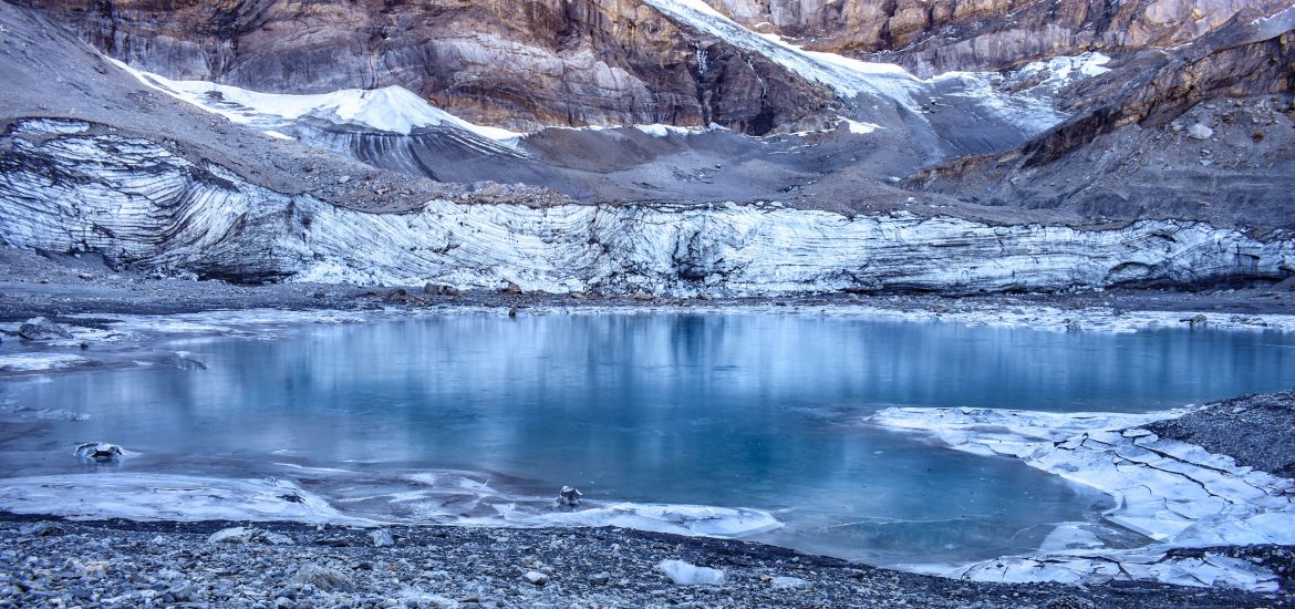
All of a sudden, the landscape changed from rich vegetation to rubble, presenting in front of me a lifeless world. On the way, there were only my friend and me and we could hear nothing but the sound of wind and of our footsteps. Soon I arrived at the viewpoint and saw the beautiful, blue Griesslisee surrounded by mountains and a glacier, all of which were in the shadow. As you can see in the pictures above, the lake was already frozen, adding more tranquility to the whole scenery. Because the viewpoint was also in the shadow, we decided to postpone our picnic to somewhere else in the sun, which was warmer. Don’t forget to take a picture of the lake even if you are going further down because according to my experience, the lake looked bluer from above than from its shore.


Follow the trail markers closely and in around 15 mins you will arrive in front of the signpost reading “Gletscherseeli”. Now, the path on your left leads back to the viewpoint and the path on your right is the second half of the round trail which continues and takes you back to Klausen Passhöhe (1952 m asl). If you want to reach the shore of Griesslisee, turn around and find your way through the glacial debris.


There’s no official trail going to the lake and when I saw the view as you can see in the 1st picture above, I turned right and started walking in the direction of the lake. There was an ascent and a descent on the way, both of which were moderate, which made me believe I made the right choice. Based on my observation and knowledge, the way leading to the lake and glacier was covered by moraine, which refers to a glacially formed accumulation of unconsolidated glacial debris (regolith and rock) that occurs in both currently and formerly glaciated regions on earth through geomorphological processes. Moraines typically form because of the plowing effect of a moving glacier, which causes it to pick up rock fragments and sediments as it moves, and because of the periodic melting of the ice, which causes the glacier to deposit these materials during warmer intervals. If the glacial debris I passed through was indeed the moraine left by the Clariden Glacier, can you imagine how far the glacier reached thousands of years ago? On the way, I had many questions. For example:
- if the small- and medium-sized rocks were carried to and deposited at their current location by the glacier, what about the large rocks? Were they also moved by the glacier or did they just fall from the mountains?
- on one of the large rocks, I saw a scale which wrote “1 m, 2 m, 3 m, 4 m, 5 m” and was probably used for measuring water level. Can the water of the seemingly small lake actually reach the rock and can its surface really reach the numbers?
If there’s an info board on site introducing this area and giving the hike an educational touch, I believe the experience will be completer.


When my friend and I finally reached the shore of the lake, my curious mind couldn’t stop asking questions. I’ve seen many glaciers but this was the first time I stood so close to one, just across the lake. To me, it was a strange but exciting new world.
- As you can see from the pictures above, the lake was frozen during my visit. From time to time I heard ice cracking. Was that caused by the moving of the glacier?
- Why did the lower section of the glacier (as you can see in the 3rd and 4th pictures) look as if it had been cut by something sharp?
- Why was the lower section of the glacier covered by debris on top?
- I saw some large ice blocks on my way to the lake. They were neither close to the lake nor close to the glacier so how had they travelled there?
- Was the hole I saw (as you can see in the 1st picture above) the so-called moulin or glacier mill (a roughly circular, vertical to nearly vertical well-like shaft within a glacier or ice sheet which water enters from the surface)?
- What did the pattern on Mountain Clariden mean? Was it related to the thrust of rocks and formation of the Alps?
I thought of many questions when I was by the lake but unfortunately I couldn’t find answers to them on the internet. Maybe after I learn more about glaciers and mountain formation through the World Heritage sites of Swiss Alps Jungfrau-Aletsch and Swiss Tectonic Arena Sardona, I can come up with the answers by myself.


Now, let’s return to the signpost “Gletscherseeli” and continue on the round trail to go back to Klausen Passhöhe. Soon after passing the signpost, you will experience the dramatic change of landscape again, from debris to lush vegetation. On the way, you will have an amazing view of the Klausenpass from its top section to its end in Linthal. What’s more, take a look at the mountain range between Gemsfairen and Tüfelsjoch (as you can see in the 4th picture above). If you have been to Elm or Flims, does it remind you of the Tschingelhörner which is famous for its Glarus Thrust and Martinsloch? It seems the lines and hole (decay) on this mountain range are clearly visible as well but I’m not sure if they are closely related to the formation of the Alps.
After returning to Klausen Passhöhe, we took the same route and drove back to Zürich. The pass, valleys, mountain ranges, and of course the frozen glacial lake were absolutely stunning, but for me, who has a really curious mind, it feels too crowded and yet unfulfilled to keep all the questions inside unanswered. I guess I became greedy after exploring the UNESCO World Heritages sites of Swiss Alps Jungfrau-Aletsch and Swiss Tectonic Arena Sardona, where I could not only admire nature but also learn about it with the help of multimedia as well as info boards erected in and around the properties. That’s for me the best way to travel – to experience, to learn and to appreciate.
After this hike, I realized Swiss mountains are more than Matterhorn, Jungfrau, Eiger, Mönch, Pilatus, Rigi and Schilthorn and Swiss lakes are more than Lake Zürich, Lake Lucerne, Lake Geneva, Lake Lugano, Lake Oeschinen, Blausee and Caumasee. In the future, I’ll keep discovering hidden Swiss treasures (both mountains and lakes) and revealing them to you.