This is part of a series of posts dedicated to the exploration of Swiss Tectonic Arena Sardona, a UNESCO World Heritage site covering an entire area of 32,850 ha. The next few paragraphs will be about the site’s universal value (the reason why it is inscribed on the World Heritage list) and a brief introduction to various hiking trails and excursions recommended by IG Tektonikarena Sardona. If you have already read some other posts related to the property, please click here to jump directly to the main content of this one.
As the UNESCO comments:
The Swiss Tectonic Arena Sardona in the north-eastern part of the country covers a mountainous area of 32,850 ha which features seven peaks that rise above 3,000 m. The area displays an exceptional example of mountain building through continental collision and features excellent geological sections through tectonic thrust, i.e. the process whereby older, deeper rocks are carried onto younger, shallower rocks. The site is distinguished by the clear three-dimensional exposure of the structures and processes that characterize this phenomenon and has been a key site for the geological sciences since the 18th century. The Glarus Alps are glaciated mountains rising dramatically above narrow river valleys and are the site of the largest post-glacial landslide in the Central Alpine region.
In order to be inscribed on the UNESCO World Heritage list, sites must be of outstanding universal value and meet at least one of the ten Criteria for Selection. Swiss Tectonic Arena Sardona, which enjoys the same award as the Grand Canyon in the USA, the Galapagos Islands in Ecuador and the Great Barrier Reef in Australia, meets
Criterion (viii) to be outstanding examples representing major stages of earth’s history, including the record of life, significant on-going geological processes in the development of landforms, or significant geomorphic or physiographic features, because
- nowhere else are the results of the processes that led to the formation of mountains as evident as they are here. For example, the “magic line” – Glarus Thrust can be identified immediately and is easily accessible;
- for more than 200 years, scientists from all over the world have been studying features that indicate mountain-building processes on this site, and their research results have revolutionized and are still revolutionizing the theories about how the Alps were formed;
- this region has a large variety of rocks, terrains and landscapes, which provide ideal habitats for various wild animals and plants and form the basis for biodiversity.
What is tectonics?
Tectonics is a specialized field in geology and concerns the process that controls the structure and properties of the Earth’s crust and its evolution through time. In particular, it describes the processes of mountain building, the growth and behavior of the strong, old cores of continents known as cratons, and the ways in which the relatively rigid plates that constitute the Earth’s outer shell interact with each other.
Within the property, there are many fabulous peaks such as Piz Segnas, Trinserhorn, Ringelspitz, Hangsackgrat, Pizol, Foostock and so on, but why is it named after Piz Sardona?
Sliced by a clear and sharp line (Glarus Thrust) on its surface, Piz Sardona is located at the center of the property, which is also the border area of the three Swiss cantons of St. Gallen, Glarus and Graubünden. Symbolically, it marks the cooperation among the Swiss federal government, the three cantons and the thirteen towns in the long-term conservation of this valuable site.
The reason why I love this site is that I can not only enjoy breathtaking views of the Swiss Alps but also gain insights into geology, in particular the formation of mountains and valleys. During the collision between the African and European continental plates, do you know how the Alps were formed and where it happened? Were the Alps created by folding or overthrust? Do you know the formation of the Alps is an ongoing process and is still happening nowadays? Why is the magic line – Glarus Thrust so important and what does it tell us about the creation of the Alps? Why are older rocks on top of younger rocks? How many different kinds of rocks can be found in the arena, where did they come from and how old are they? Do you know rockslides also contributed to the formation of the Alps and the largest rock avalanche in the Central Alps is the Flims rockslide? To find answers to most of the above questions, I propose to you three ways. The first one, which is my favorite, is to set your foot in the region and read the info panels on site while witnessing the actual miracles. The second one is to visit Visitor Center Glarnerland and Visitor Center Elm, which host permanent exhibitions related the geological history and knowledge of the property. If it’s inconvenient for you to reach the site, please click here to visit the official website of UNESCO – Sardona, which in my opinion provides a comprehensive introduction to the property and, accompanied by pictures and graphs, vivid explanations for the spectacular phenomena.
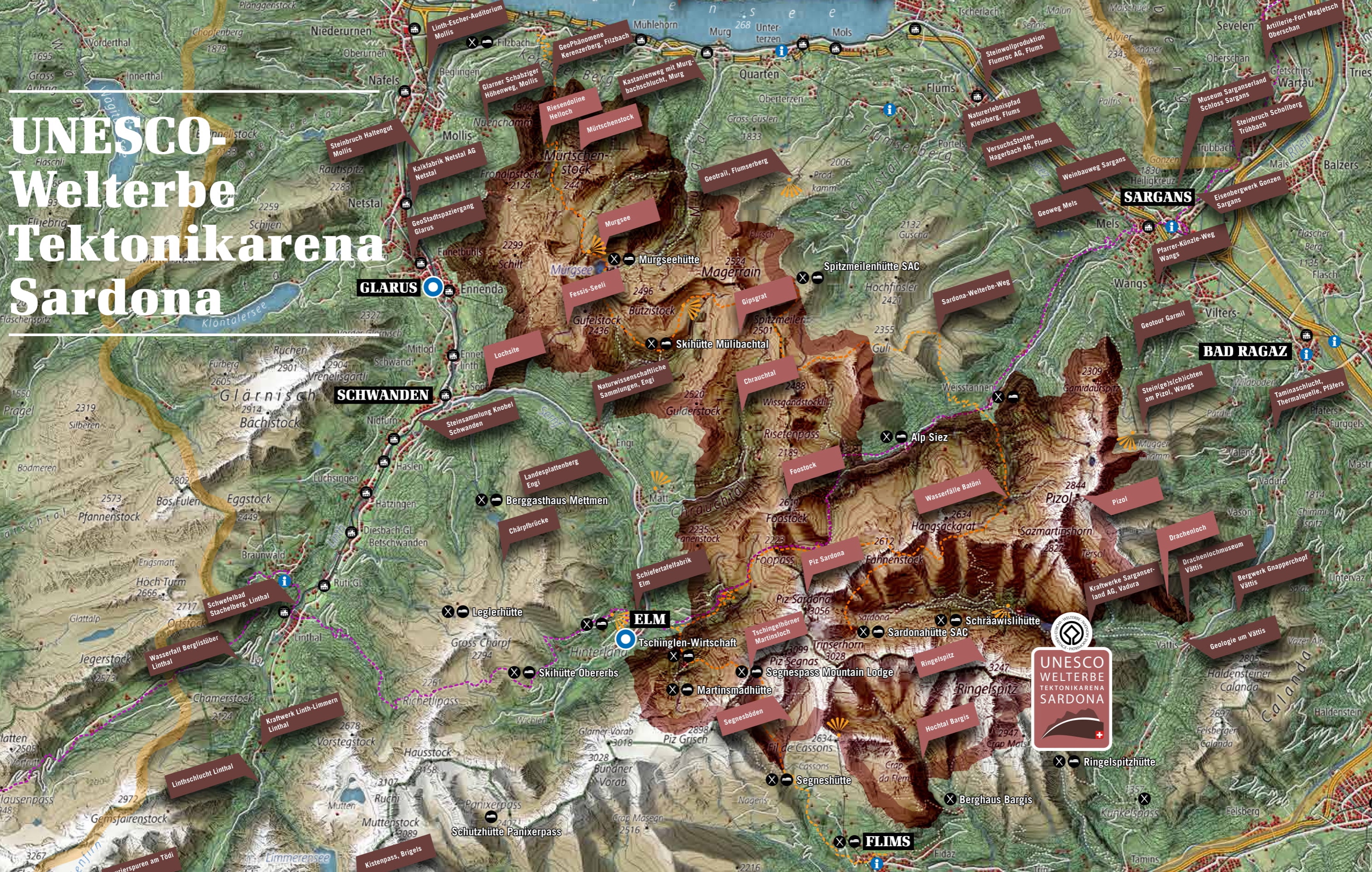
As you can see from the map above, this site covers a large area (32,850 ha) and similar to another UNESCO World Natural Heritage site in Switzerland – Swiss Alps Jungfrau-Aletsch, it can be visited and explored through numerous hiking trails and excursions. When I visited Elm, I got from the Visitor Center a brochure called “UNESCO World Heritage Tectonic Arena Sardona – Hiking and Excursion Tips”, which provides a brief introduction to the property and presents the famous Sardona World Heritage Trail, which allows hikers to walk through the core of the site and learn about geology in 6 days, 6 Geo hiking trails, 6 Geo excursions and 6 Geo phenomena, etc. As far as I know, the Heidiland holiday region, the Elm holiday region, and Flims are particularly popular among visitors. In the autumn of 2016, I hiked around Pizol, but because the peaks were almost all covered in snow, I planned to revisit the area. In 2018, after hiking from Tschinglenalp below the famous Martinsloch (Martin’s Hole) to Firstboden and back, and taking the “Höhenweg Naraus – Segneshütte – Alp Nagens”, on which the entire Flims Valley, the Segnesboden (the most beautiful braids of Flims) and the Glarus Thrust can be seen clearly, I retook the Pizol Panorama Höhenweg and successfully challenged the famous 5-lake hiking trail. Please don’t think that you can only explore Tectonic Arena Sardona from the three regions I mentioned above. In the north of the site, you can see the “Riesendoline Helloch“, which had originally been a cave but collapsed later, and at Skihütte Mülibachtal, you can see the Gipsgrat, a beautiful mountain range.
1. Pizol 5-lake Hiking Trail


In 2016, after visiting the Pizol region briefly, I knew I would return for its beauty and explore it more. What I didn’t realize is it’s also the gateway to the impressive UNESCO World Heritage site Swiss Tectonic Arena Sardona, which gave me even more motivation to go back. The 5-Seen-Wanderung (5-Lake Hiking Trail) here is one of the most famous and beautiful hiking trails in Switzerland and when I was taking the Expedition Tschinglen in 2018, I met a local guy who strongly recommended it and assured me that it’s not difficult at all. I was a bit doubtful because on the official website of Pizol, it said the total distance of the trail was 10.7 km and the difference in altitude was ascent 750 m / descent 1,100 m, which didn’t sound easy at all. However, I saw lots of friends taking it and posting pictures on the internet, so I thought, “How difficult could it be?” Well, the truth is it’s not as difficult as I was afraid but quite tiring because of all the ascent and decent, but the view along the way was absolutely amazing. I saw fabulous lakes of different colors and magnificent peaks, some of which are covered in snow all the year round. In this chapter, I’ll first give you some practical information and tips and then I’ll introduce and show you the trail in detail.
1.1 Practical information
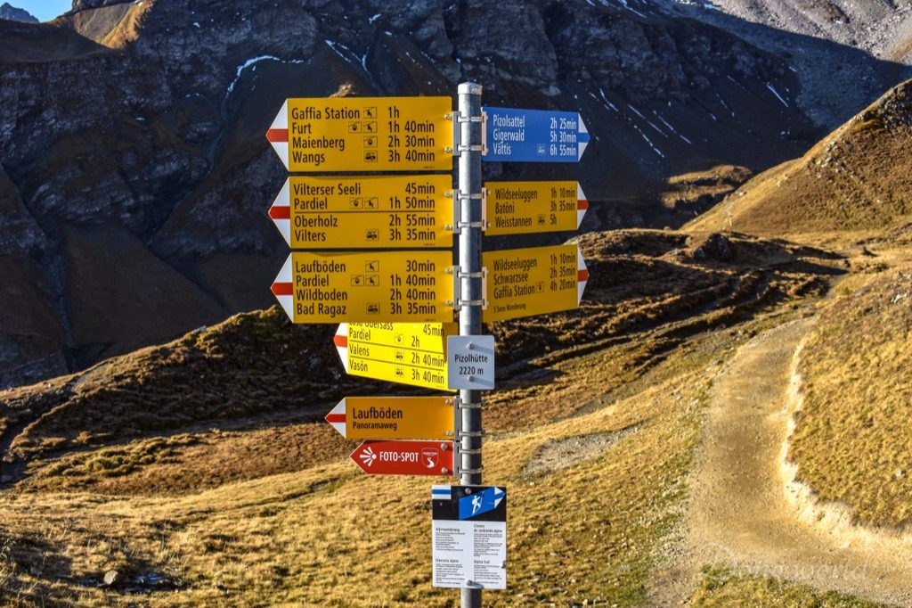
In Pizol, there are many cables cars and chairlifts taking you to various mountain stations but the ones I used during the specific hike were cable cars between Wangs Talstation Pizolbahnen and Furt and chairlifts between Furt and Pizolhütte.
Operation hours and ticket prices:
For information about the schedule of cable cars and chairlifts in Pizol (Wangs – Bad Ragaz), please click here.
5-Lake hiking ticket is available and it costs:
- Adults: CHF 44.-
- Children (6 – 17 years old): CHF 22.-
- Adults with GA or Halbtax card: CHF 22.-
Please note:
- the trail is only open in the summer season;
- during lunchtime, all the cable cars and chairlifts will stop running for an hour so make sure you don’t need to use them at that point;
- at each cable car or chairlift station, you should see a board showing the time of lunch break (for example between Wangs and Furt the lunch break is 12:00 – 13:00 and between Furt and Gaffia the lunch break is 12:20 – 13:20 etc.) and of the last cable car or chairlift going down;
- pay attention to the time when the last cable car or chairlift goes down and do NOT miss it;
- keep the ticket with you because you’ll need it to exit the lower cable car station at Wangs;
- the ride on the way is rather long and it takes around 1 hour to reach Pizolhütte from Wangs and another hour to go back;
- most of the chairlifts are open (exposed to the air) so if you visit Pizol in the early spring or late autumn, make sure to wear warm clothes and even hats and gloves if necessary;
- if you want to know the prices for single rides, family cards, one-day or multi-day passes, seasonal passes etc., please click here.
1.2 Tips


My itinerary was: Zurich HB – [train + bus] > Wangs Talstation Pizolbahnen – [cable car] > Furt [chairlift] > Gaffia – [chairlift] > Pizolhütte – [hike] > Wangersee – [hike] > Pizolhütte – [hike] > Wildsee – [hike] > Schottensee – [hike] > Schwarzsee – [hike] > Baschalvasee – [hike] > Gaffia – [chairlift] > Furt – [cable car] > Wangs Talstation Pizolbahnen – [bus + train] > Zurich HB.
- The total distance of the trail is 10.7 km, which lies between 2,227 and 2,504 m above sea level and takes around 5 hours to finish. The difference in altitude is: ascent 750 m / descent 1,100 m;
- as an amateur hiker, I would say the difficulty level of the hike is between medium and difficult. I saw old people, children and parents carrying infants on the way so it’s certainly not a dangerous trail. However, due to some of the challenging ascents and descents, it was quite tiring for me;
- in the top section, the route runs through scree and rocky areas, so you are recommended to wear high hiking boots. Those areas, in particular the downhill ones, can be rather slippery so you should be careful;
- I hiked on a sunny day (19th October 2018) but the temperature was quite low. On the way up from Wangs to Pizolhütte I was wearing a thin winter jacket, scarf and gloves. During the hike, I changed to t-shirt and shorts because most of the trail was in the sun and the exercise made me sweaty. Nevertheless, in the shadow, I felt quite cold;
- sun cream is a must;
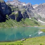
- the highlights on the way are the five crystal clear lakes (Wangsersee, Wildsee, Schottensee, Schwarzsee – and Baschalvasee) and a unique view of the UNESCO World Heritage site Sardona. Between Schottensee and Schwarzsee, there’s a viewpoint with an info board where you can see clearly the Glarus and Grisons mountains, the Rhine Valley of St. Gallen and on a clear day, Lake Constance;
- though there are not many World Heritage Sardona info boards on the way, most of the hiking trail is located inside the property;
- at Furt, Gaffia and Pizolhütte there are restaurants, and at Gaffia and Wangs Talstation Pizolbahnen there are public toilets. On the hiking trail from Pizolhütte to Gaffia there are no restaurants, toilets or fountains so you’d better take some snacks and enough water with you and use the toilet in advance;
- IMPORTANT! Many people are confused because they see that on the main trail there are only four lakes. I had the same question and it turned out the first lake was called Wangsersee and was located in the opposite direction of the main trail. If you follow the signpost at Pizolhütte, which shows where the 5-Seen-Wanderung starts, you will only visit four lakes. Take a hiking map from the ticket office and hike from Pizolhütte to Wangersee and back to Pizolhütte and then follow the main trail. In this way you will visit all the five lakes;
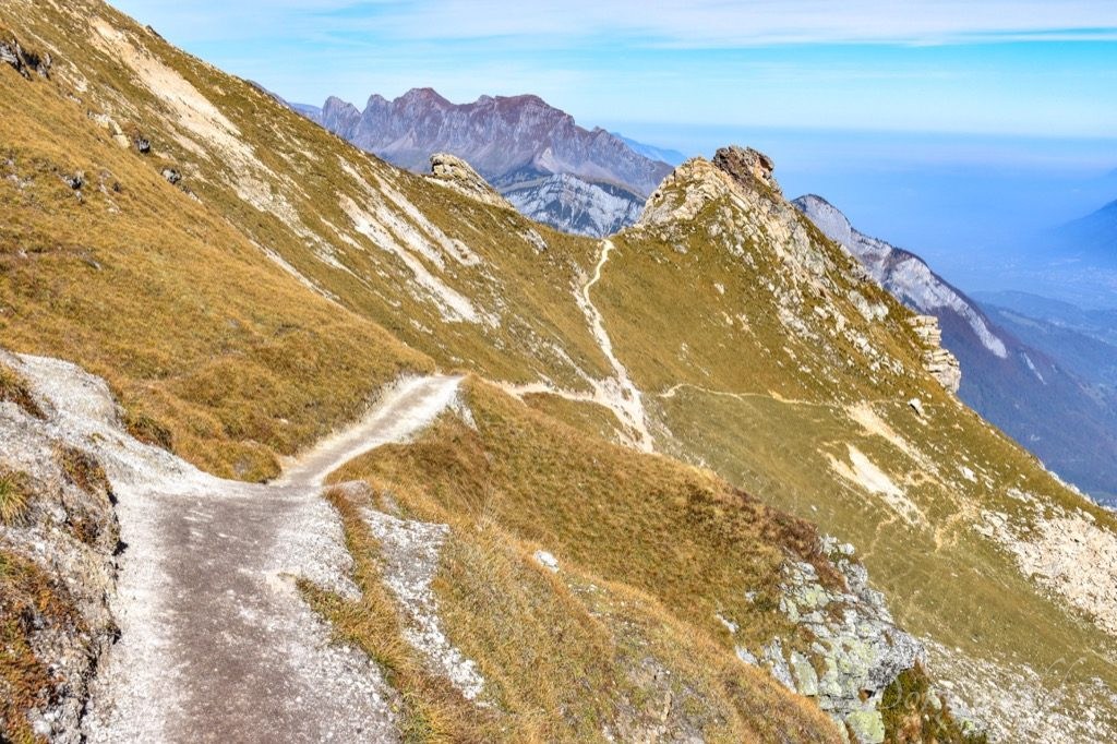
- if you don’t plan to take the Pizol Panorama Höhenweg anytime soon, I suggest you hike for another 10 – 15 mins from Wangersee to the “Tagweidlichopf” viewpoint (2,275 m asl), which privides an incredible, panoramic view and was chosen as one of the 40 photo spots for the Grand Tour of Switzerland. Also from here, you can learn a lot about the formation of the Alps;
- last but not least, leave enough time for the hike because the cable car and chairlift rides take quite some time (around 1 hour one way) and the hike itself takes around 5 hours. If you have enough time and can hike leisurely, it will be much easier.
1.3 On the 5-lake hiking trail
Wangs to Pizolhütte (by cable car and chairlift)


Cable cars run constantly (except for lunch break) between Wangs Talstation Pizolbahnen and Furt and chairlifts run constantly (except for lunch break) between Furt and Gaffia and between Gaffia and Pizolhütte. What impressed me was that the staff were super friendly and they always tried their best to answer my questions. I arrived early in the morning and the cable car kept me warm. However, the moment I sat on the chairlift and started the ride, I felt really cold. I felt exactly the same two years ago on 22nd October, 2016, when I first explored the region, so my advice is if you want to come here in the autumn, check the temperature in advance and keep warm. After all, the chairlift ride in the open air takes more than half an hour. One thing I’d like to emphasize here is at Furt, there’s a water park which I explored two years ago and I believe it’s great place for kids, especially in the summer. If you want to know more about it please click here.
Pizolhütte to Wangersee


Once getting off at the top station, don’t run to the west to the main 5-lake hiking trail because otherwise you will miss one lake. The actual starting point of the trail is Wangersee (Wanger Lake), which is to the east. Next to the Pizolhütte station, you will find two benches, where you can sit and enjoy a great view of the Churfirsten mountain range in the Canton of St. Gallen, the Rhine Valley of St. Gallen and on a clear day, even Lake Constance. Between the two benches you will see a signpost showing in which direction and how far from here some of the famous cities such as Geneva, Tokyo, Vienna, Munich, Madrid, New York and San Francisco are. The hike between Pizolhütte and Wangersee is actually part of the Pizol Panorama Höhenweg (Pizol Panorama High-Altitude Trail), which I will introduce to you in detail in the next post.
Next to Wangersee, you will see a World Heritage Sardona info board, which explains where its water came from. When the earth was formed 4.5 billion years ago, its surface was so warm that there were no lakes, seas or rivers. All water was held as water vapor in the atmosphere. When the earth cooled down gradually, it started to rain around 4 billion years ago. It kept raining for about 40,000 years and oceans, lakes and streams formed. So did the Wangersee. I really love these info boards because they explain the history of the earth and spectacular geological phenomena in an east-to-understand way, which gives the entire hiking experience an educational touch. Personally, I recommend you going a bit higher on the trail because firstly, you’ll get a better view of the lake and secondly, you will soon reach another info board.
As you can see in the 5th picture above, looking in the direction of Pizolhütte, the mountains in the background are rough, sharp and rugged while the terrain in the foreground is strikingly gentle and hilly. There’s a simple geological explanation for the difference. The mountains are made up of verrucano rock while the terrain consists of flysch rock. Verrucano and flysch were shaped differently by the force that shaped the landscape. When flysch erodes, fine silt is formed, which is one of the reasons why the Wangersee exists. It seals the ground so that water can only seep away to a limited degree. Another interesting fact about the lake is the municipal border between Vilters-Wangs and Bad Ragaz runs through the middle of it.
“Tagweidlichopf” viewpoint (optional)


The “Tagweidlichopf” viewpoint is a highlight of the Pizol Panorama Höhenweg and is only 10 mins away by foot from Wangersee. If you don’t plan to take the Höhenweg in the near future, I think you should visit the viewpoint, which provides an incredible panoramic view of the surrounding mountains such as Pizol, Piz Blaisun, Piz Kesch, Piz Ducan, Älplihorn, Piz Linard, Schesaplana, Säntis, the Churfirsten mountain range and so on and of the Rhine Valley. What’s more, a new photo spot was added here for the Grand Tour of Switzerland with a view of the Pizol summit and its glacier. If you are interested in geology, on the 360-degree info board (as you can see in the 1st picture above), you will learn a lot about the history of the earth. Did you know that the verrucano rock here formed around 250 – 300 million years ago in a hot desert area and is one of the oldest types of rock in this region? Did you know though Pizol is the highest mountain in the Canton of St. Gallen, the Ringelspitz is the highest peak? Did you know the Glarus Thrust is the most important thrust in the world? Did you know in the middle of the Grisons, parts of the African plate can be found? Did you know Matterhorn and Schesaplana are relics of the African plate? Did you know the Rhine Valley was once filled with mighty glaciers? In my next post about the Pizol Panorama Höhenweg, I’ll tell you more. After visiting Wangersee (or the viewpoint if you choose to), remember to return to Pizolhütte and follow the signpost to the east of the restaurant (as you can see in the 5th picture above) and then, the real adventure begins.
Pizolhütte to Wildsee


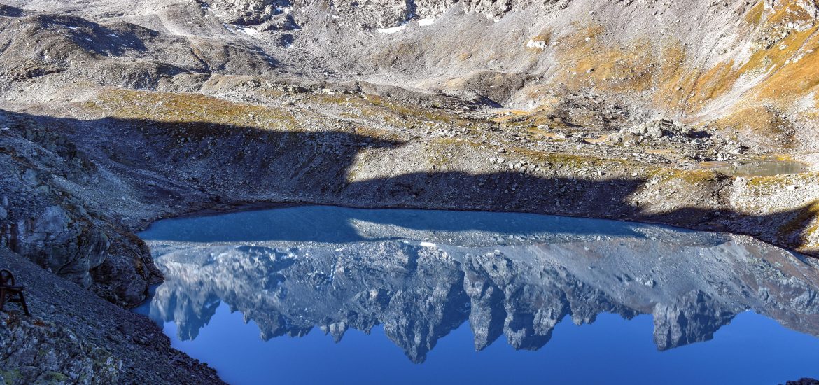
After passing the signpost, you will soon enter the UNESCO World Heritage site Sardona and see another info board which is about the Pizolgletscher (Pizol Glacier). I guess the reason why the board is erected here is the 5-Seen-Wanderung isn’t accessible to everyone and it takes quite some effort to reach the Wildssee, which is in my opinion the best spot to admire the Pizol mountain and its glacier. This also explains why on the rest of the trail there are no info boards anymore. Considering the difficulty level of the trail, I was surprised there were so many hikers (as you can see in the 1st picture above). I guess its fame and charm just made us braver and more adventurous. As you can see in the 2nd picture above, from Pizolhütte to Wildseeluggen (where you have a great view of the Wildsee, Pizol, Pizolgletscher, and Graue Hörner), the ascent is quite challenging. I even felt a bit hopeless because the zigzag path was quite long and didn’t seem to have an end. The only thing that kept me going were my friend’s words “Wildsee is in my opinion the most beautiful of all the five lakes.” and after seeing it, I totally agree with her.
When I first arrived, the lake was still in the shadow. If you like photography, this is the best moment to capture the reflection of Pizol and Graue Hörner on the lake because in the sunlight, the color of the lake becomes very bright and you can’t see their reflection clearly anymore. As time went by, the sun began to shine on the lake, which revealed its true color. I was greatly attracted by its milky turquoise water and decided to wait (while having some snacks and recharging myself) until the whole lake was in the sun (around noon). As you can see in the 5th picture above, the scenery is simply breathtaking. By the way, if you want to have a nice souvenir photo of yourself, there’s a nice spot a bit down the trail. You will find it easily because it’s very popular on the internet and almost everyone who passes by will stop there. Just be careful when you go down because the short path is covered in screes and is quite slippery.
Now, since we are at the best viewpoint of Pizol Glacier, I’ll introduce it to you based on the information I read from the info board I mentioned above. Once a mighty cirque glacier, the Pizolgletscher might soon be completely gone. From a graph on the board, you can see its change in length between 1893 and 2008. During a timeframe of 115 years, it shrunk around 350 meters, which corresponds with an average shrinking rate of 3 m/year! Take your time to admire the glacier today because in a few years, it might be too late.
Wildsee to Schottensee
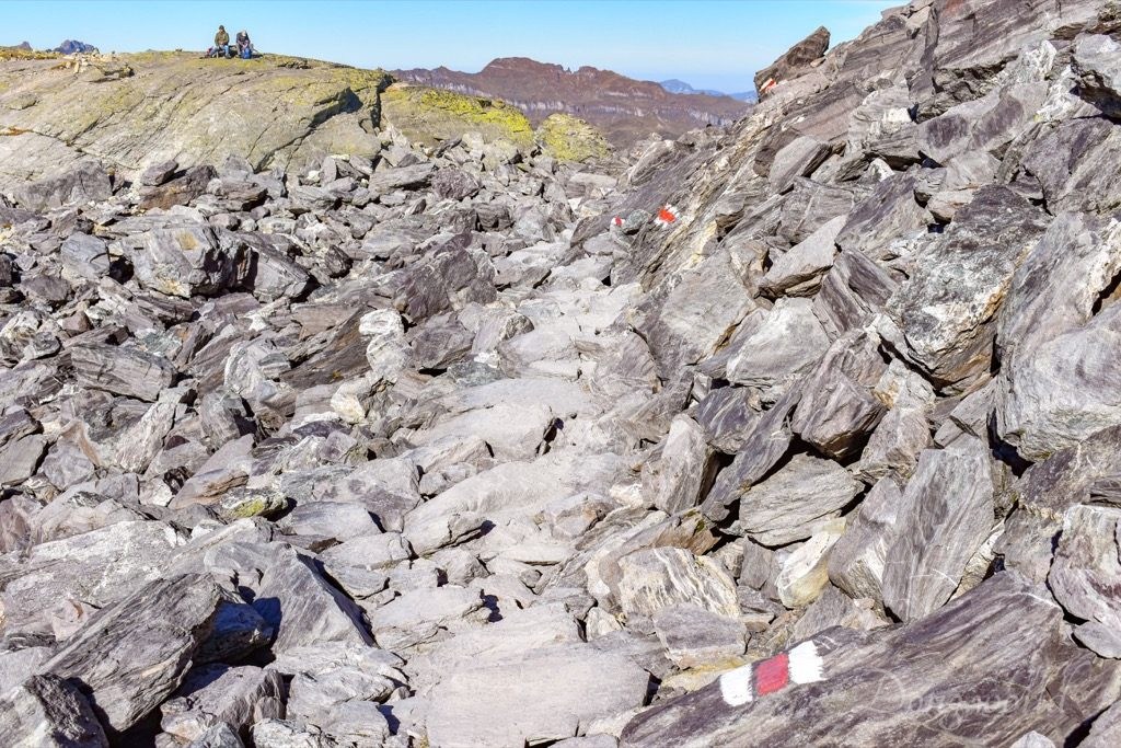


From Wildsee to Schottensee, there’s a descent which is not very steep. However, there are some rocky sections (as you can see in the 1st picture above) so you are recommended to wear high hiking boots. Always follow the trail sign because the path is not always clearly visible. In my opinion, the best view of Schottensee is from above before the decent and when you’re next to the lake, you’ll get a good view of Hochwart.
Schottensee to Schwarzplangg


There’s an ascent from Schottensee to Schwarzplangg and the first half is quite easy while the second half is a bit tiring. Having seen three lakes already, now it’s time to admire some mountains. I like this viewpoint very much because firstly it provides a great view of the World Heritage site Sardona and secondly, there’s an info board helping me recognize the mountains. I wrote the names of the famous mountains as caption under each of the pictures above and I’m sure you’ve heard many of them.
Schwarzplangg to Schwarzsee

There’s a descent from Schwarzplangg to Schwarzsee and it’s not steep. However, I remember there was one section which was a bit slippery because of screes. Again, in my opinion, the best view of Schwarzsee is from above during the descent and when you’re next to it, you can see clearly the Schwarze Hörner. It is said on the official website that at Schwarzsee it’s possible to spot ibex, chamois and with a bit of luck, even eagles, but unfortunately, I didn’t see any. I guess in order to see eagles, you probably need binoculars.
Schwarzsee to Gamidaurspitz


From Schwarzsee to Gamidaurspitz, there is a moderate ascent, which is easily manageable. What impressed me most at Gamidaurspitz was the large amount of cairns, which refer to human-made piles (or stacks) of stones. Cairns have been and are used for a broad variety of purposes, from prehistoric times to the present. In modern times, they are often erected as landmarks, a use they have had since ancient times.
Gamidaurspitz to Baschalvasee


From Gamidaurspitz to Baschalvasee, the descent is smooth and easily manageable. Between Gamidaurspitz and Baseggla, which is 15 mins away from Baschalvasee, I had a great view of the peaks of the World Heritage site Sardona such as Piz Sardona, Tödi, Hausstock, Clariden, Foopass, Kärpf Foostock and so on, of the Churfirsten mountain range, of the Rhine Valley, of the municipalities of Vilters-Wangs and Bad Ragaz, of the mountain hotel Gaffia, and of the mountain station of Furt. Though the fog in the distance obstructed my view of Lake Constance, it made the valley more mysterious and picturesque. I remember between Baseggla and Baschalvasee, a tiny section was a bit slippery because of screes.
Baschalvasee to Gaffia


From Baschalvasee to Gaffia, the trail is a bit narrow but not difficult (as you can see in the 3rd and 6th pictures above). On the way, I could see Gaffia most of the time and it always seemed to me that it could be reached within the next 10 mins. However, one turn after another, it took me around 45 mins to reach the final destination. Looking back, I couldn’t believe I actually hiked down from that trail.
All in all, I’m proud of myself taking the 5-Seen-Wanderung and it’s certainly one of my best and most unforgettable hiking experiences. As I said at the beginning of the chapter, the highlights along the way are the five lakes, the Schwarzplangg viewpoint, the view of the surroundings and the ever-changing landscapes. As a UNESCO World Heritage fan, it satisfied me a lot to actually walk on the area included in the Swiss Tectonic Arena Sardona and to catch a glimpse of most of the most famous peaks all together in the property.
2. GEOTour Garmil Mountain Hike


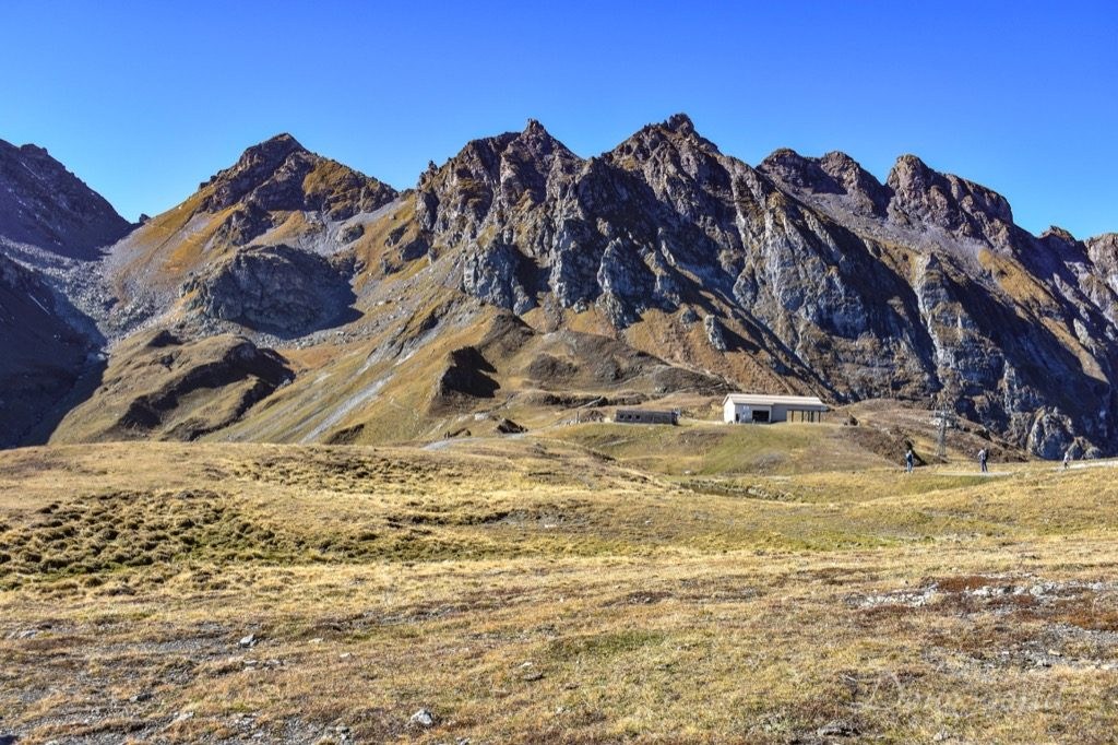
Close to Alte Alp Gaffia (a restaurant 5 mins away from Gaffia chairlift station), where you can sit down comfortably for a drink or meal after the tiring 5-hour hike, I found another World Heritage info board, but unfortunately it’s not related to the 5-Seen-Wanderung anymore. In fact, it marks the beginning of a new trail called multimedia GEOTour Garmil, which lies mostly inside the Swiss Tectonic Arena Sardona and allows visitors to have easy access to the world of geology. Can you imagine? Every time you enter or exit the Gaffia mountain station, you are standing right on the famous Glarus Trust. This is because the station itself is located on the world-famous geological phenomenon. The thrust is clearly visible on Piz Sardona and Pizol but here, unfortunately, it’s buried under colluvial deposits and vegetation. It goes along the valley’s sidewall almost all the way down to Sargans.
Though I didn’t take the whole trail and returned after around 45 mins because of time limit, I became interested in it firstly because of the clear mountain streams and beautiful rocks with amazing colors, and secondly because I could learn more about the World Heritage site. As I read from the official website, the hike can be experienced through multimedia, which means at nine station, you can use your the smartphone to listen to and watch exciting information about the geological history of Garmil. The app recommended is called “Wanderapp“, on which unfortunately the information is only in German. I haven’t figured out how to use the app to listen to the information yet, but next year when the snow disappears, I’ll try to take the complete tour and write another post introducing it in detail to you. Some other information that I learnt from the official website and you might be interested in is:
- route: Gaffia – Basürla – Garmil – Fürggli – Vollenplangg – Furt
- distance: 6.6 km
- altitude: 2,002 to 1,505 m asl
- difference in altitude: ascent 283 m / descent 628 m
- hiking time: 2.5 hours
As I mentioned at the beginning of the post, Swiss Tectonic Area Sardona covers an entire space of 32,850 ha and can be explored by numerous hikes and excursions. In this post, I focused on one of the most famous and beautiful hikes in Switzerland, that is to say, the 5-Lake Hiking Trail, on which four lakes, numerous mountain peaks and ever-changing landscapes within the World Heritage site can be appreciated. In addition, I also introduced briefly the multimedia GEOTour Garmil, which I hope I can complete when the next summer season comes. In the future, I’ll keep discovering new, interesting and impressive hiking trails and destinations in and around the property, and I’ll make sure to keep you updated. To be continued…