In my previous post about Stari Grad, I focused on the attractions and cultural heritage sites in the town, and in this post I’ll introduce in detail my cycling tour through the plain. The first chapter will be about the property’s universal value, or in other words, the reason why it is inscribed on the UNESCO World Heritage list; the second chapter will be about some personal tips concerning how to explore the plain; and the third one will be about my own experience including what I saw and what I learnt. If you have read my previous post, please click here to skip chapter one.


1 The universal value of Stari Grad Plain
As the UNESCO comments:
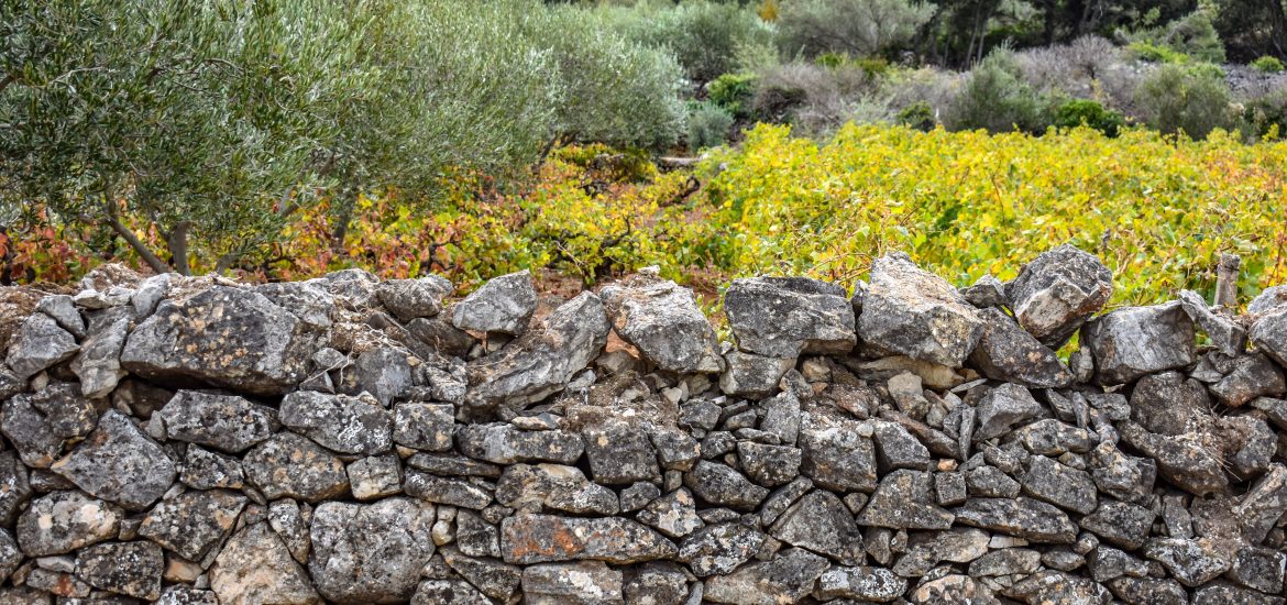
Stari Grad Plain on the Adriatic island of Hvar is a cultural landscape that has remained practically intact since it was first colonized by Ionian Greeks from Paros in the 4th century BC. The original agricultural activity of this fertile plain, mainly centring on grapes and olives, has been maintained since Greek times to the present. The site is also a natural reserve. The landscape features ancient stone walls and trims, or small stone shelters, and bears testimony to the ancient geometrical system of land division used by the ancient Greeks, the chora which has remained virtually intact over 24 centuries.
In order to be inscribed on the UNESCO World Heritage list, sites must be of outstanding universal value and meet at least one of the ten Criteria for Selection. Stari Grad Plain meets:
- Criterion (ii): to exhibit an important interchange of human values, over a span of time or within a cultural area of the world, on developments in architecture or technology, monumental arts, town-planning or landscape design, because the land organization system which is based on geometrical parcels with dry-stone wall boundaries and completed from the very first by a rainwater recovery system involving the use of tanks and gutters, is exemplary and bears witness to the distribution of the Greek geometrical model for the dividing up of agricultural land in the Mediterranean world. This system known as chora is today perfectly identifiable, and has changed very little. The built structures of the stone walls are authentic, with the same basic dry-stone wall materials being used and reused since the foundation by the Greeks.
- Criterion (iii): to bear a unique or at least exceptional testimony to a cultural tradition or to a civilization which is living or which has disappeared, because the agricultural plain has been in continuous use, with the same initial crops being produced, for 2400 years. This bears witness to its permanency and sustainability down the centuries;
- and Criterion (v): to be an outstanding example of a traditional human settlement, land-use, or sea-use which is representative of a culture (or cultures), or human interaction with the environment especially when it has become vulnerable under the impact of irreversible change, because the agricultural plain and its environment are an example of very ancient traditional human settlement, which is today under threat particularly from rural depopulation and the abandonment of traditional farming practices.
2. How to explore the plain


As I mentioned in the previous post, if you want to thoroughly explore this property including the town and the plain, one day is not enough. For me, I spent almost a whole day on the plain. Stari Grad is on an island so it’s not very convenient to drive here. I think, as a normal tourist, the easiest way is by ferry. Jadrolinija is a state-owned sea shipping company and it connects Croatian islands to the mainland by operating regular passenger and cargo transport services. If you want to check the schedule please click here. I took a very early ferry from Split and on the cruise, I saw the beautiful sunrise on the Adratic Sea, which was my reward for getting up so early. From the ferry terminal of Stari Grad to the old town I walked for around 30 mins along the promenade. The path was so scenic that I even forgot how much time I spent on the way. If you want to know how to visit the old town, please read my previous post, and if you want to know how to explore the plain, now I’ll give you some suggestions.
- In my opinion, the most efficient way to explore the plain is by bike. In the town, there are several bike rental points and the one I chose charged 13.5 euros for a mountain bike for 1-2 days. If you just plan to cycle on the asphalt and macadam pavements, city bike is good enough, but if you plan to cycle on the cobble path or uphill, mountain bike is a better option. Don’t forget, your ID card or passport is needed as deposit.
- For planning and guiding your tour, the large map which you can get from the tourist information center for free is very useful. On it, all the routes (asphalt, macadam, cobble and pedestrian paths) and sites (including archaeological sites, churches, and ethnographic heritage) are marked and on its back, briefly introductions are provided. I recommend you to read about the sites first, decide which ones you want to visit, mark them on the map and then design your own itinerary.
- Another factor you should take into consideration when designing the route is your cycling skill. I’m not good at cycling and this was actually my first tour by bike, so I tried to avoid the asphalt path to avoid cars and trucks. The roads were not busy and even as a beginner, I felt quite safe most of the time.
- I visited three villages on the hill but unfortunately didn’t find any restaurant that was open. Therefore, I cycled to a town (Vrboska) at the other end of the plain and had lunch. It’s a rather touristy town and there were many food choices. Take enough water because cycling for hours can make you very thirsty, but if you think it’s too heavy to carry all the way, you can also buy it in Vrboska.
- It only takes around 25 mins to cycle across the plain through the fastest route but depending on how many sites you want to see on the way, the tour can be much longer. Plan well in advance and don’t miss the latest opportunity to return the bike or leave the island.
- Info boards are scattered on the plain, most of which are about history of the different paths.
- I cycled on the plain on 5th October, and it was a bit cold in the morning. When the sun came out, I got a bit sweaty because of the exercise and changed to t-shirt. In general, I would say the thin winter jacket and t-shirt combination was a good choice.
- Most of the sites on the plain were not difficult to find but some of them were not located at the exact spots as shown on the map. Sometimes you might need to have a look around.
- If unfortunately you are unable to explore the plain, at least visit the Pharos Archaeological Site and its exhibition center. In 2018, it hosted a special exhibition dedicated to the 10th anniversary of Stari Grad Plain’s inscription on the UNESCO World Heritage list, which introduced the property and some specific sites within such as the Chapel of St. Jelena (Helena), Carevac Archeological Site, the dry-stone walls, remains of the Greek watchtower on top of Maslinovik Hill, and ruins of a Roman villa in Mirje.
In the next chapter, I’ll first introduce the plain in general and then focus on the sites that I visited. Hopefully after reading it, you can have some ideas about how to design your own route.
3. Cycling through the plain


The general introduction of the plain below will be based on what I read from the info boards at Pharos Archaeological Site.
Stari Grad Plain, 5.5 km long and 2 km wide, is the largest plain on the Adriatic islands. Throughout history, it was referred to by many names. For example, Hóra Faru by the Greeks, Ager Pharensis by the Romans and Campus Sancti Stephani in the Middle Ages. Its geometrical layout dates from 24 centuries ago, when the Greek colonizers divided the plain into 75 rectangular plots of 1 stadion * 5 stadia (about 180 m * 900 m), which you can see on the 1st picture above. The starting point of land division, known as omphalos (Greek for navel), is located near Dračevica, the only pond on the plain. The plots were allocated by casting of lots and owners marked their lands with boundary stones. So far, the only one found on the plain bears the name of Mathios (son) of Pitheas. Though the Greeks controlled the most fertile part of the island, the indigenous people still lived in their hillforts. In order to protect the plain, which was the key to their economic prosperity, the Greeks built a defense system consisting of three watchtowers (at the sites of Maslinovik, Tor and Purkin kuk).
From the 1st century BC onwards, the Greek land division changed because the Romans divided the large plots into smaller ones and built their villa rustica (a term used by the ancient Romans to denote a villa set in the open countryside, often as the hub of a large agricultural estate) on the Greek estates. Remains of some of the villas have been discovered and researched and nowadays are exhibited to the public. The Hvar Statute of 1331 mentions ancient roads which were preserved on account of continuous cultivation of the land in the Middle Ages. Names of the landowners from that period of time such as Desislav, Gojmir, Grdoš, Grubša, Hranko, Hvališa, Premil and Prvoš testify to the complete Slavicization of the island.
On the southern rim of the plain are the oldest villages on the island, namely, Dol sv. Marije (Dol of St. Mary), Dol sv. Ane (Dol of St. Anna) and Vrbanj, and on the eastern rim the lovely town of Vrboska, which was founded in the 15th century as the harbor of Vrbanj. I visited all of them and later I’ll show you some pictures.


As the most fertile plain on the island of Hvar, Stari Grad Plain plays an important role in the island’s agricultural production. The three characteristic Mediterranean crops – grapes, olives and wheat (the so-called “Mediterranean triad”), have been present here during all historical eras though in different ratios, depending on the socio-economic conditions. Besides the aforementioned triad, other Mediterranean crops also grow here such as figs, almonds, carob trees and lavender. Lavender was mostly planted here at the beginning of the 20th century, when certain disease destroyed part of the grapevines plantations. Experts from the Faculty of Agriculture, University of Zagreb conducted a study and found out that the protected area is 39% agriculturally active, of which 23% is olive groves, 12% vineyards and 4% planted with other crops. The rest of the space is in the state of plant succession, with Grass and bushes growing on the lower part and Mediterranean maquis and forests of Aleppo pine (Pinus halepensis) on the upper part. I tried to buy some olive oil from the plain but found only one souvenir shop selling it, and it seemed wine and lavender from here were more popular. As told by the shop owner, authentic products from the plain are always marked with a round sign reading “plodovi starogradskog polja fruits of the plain”.
Now, I’ll show you the sites I visited during my own excursion.
3.1 Chapel of St. Jelena (Helena)

The chapel was constructed in the 15th century by an unknown architect and was dedicated to St. Helena, the patron saint of all Christians and archaeologists. In history, St. Helena is known as the mother of Emperor Constantine and she became a saint during a pilgrimage to Jerusalem when she discovered, according to legend, the tomb of Jesus and the cross upon which he was crucified, the True Cross. The chapel is very simple in its layout – a rectangular building with stone slate roofing, but two reliefs embedded above the entrance are very interesting. One is a stylized depiction of St. Helena with a royal crown on her head and the True Cross in her left hand, which (the relief) bears the inscriptions: “the discovery of the sacred cross” and “St. Helena pray for us”. The other relief depicts a walking bear, which was most likely taken from the surrounding area or brought from the town. The bear symbolizes the god Veles in Slavic mythology. It is also possible that an earlier shrine (7th – 9th centuries) was erected here dedicated to Mokoš, the Slavic goddess of fertility. After converting to Christianity, chapels dedicated to St. Helena were frequently erected on sites formerly dedicated to Mokoš.
3.2 Greek paths and dry-stone walls of the plain


The property is inscribed by the UNESCO mainly because it’s one of the best preserved examples of Greek land division, which is still visible nowadays as a network of roads bounded by dry-stone walls. The process of land measurement is not known to us directly from Greek sources but from the Roman ones. The measuring and staking out (construction surveying) of straight lines and right angles were carried out using a groma and measuring sticks, which had notches carved into them indicating length. First, a starting point of the division was designated, a point which offered the best view of the surrounding area. Using the groma, every stadion (180 m) along the main north-south axis was marked as was every 5th stadion on the east-west axis. It’s been established that division of land in Stari Grad Plain was carried out exactly in this manner. The point where the two main axes intersect is the omphalos, where the measuring started. It is marked No. 8 on the map. The roads, which also served as boundaries of plots of land, were made following the main lines of the land division. Due to the location of the plain, the entire system deviates by 12 degrees from the east-west line, which allowed for optimal distribution of the land.
During my trip, I saw some info boards erected on the paths introducing them.
- Put Matijev (Mathio’s Path) – This path is the main vertical axis of Greek land division on Stari Grad Plain and is named after a Greek who owned a plot of land. His name is found on one of the boundary stones and is the only one found so far. The inscription (land of Mathios (son) of Pytheas) dates from the 4th century BC and is direct evidence of Greek land division on Stari Grad Plain. The original is in the Archaeological Museum in Zagreb and its copy is in the Museum of Dominican Monastery in Stari Grad. After going through the omphalos, Mathio’s path continues north towards Dračevica and finally leads to the Greek watchtower on the site of Maslinovik.
- Put Demetrija Farskog – The path of Demetrios of Pharos is the main horizontal axis of Greek land division on Stari Grad Plain and is named in honor of Demetrios of Pharos, the most prominent historical figure who came from this area. He was ally of the Illyrian queen Teuta, who in the late-3rd century BC controlled a large part of the Adriatic coast and conquered some of the Greek cities. Illyrian piracy and interference with commerce drove Rome, the growing strength of the Mediterranean, to send for the first time its fleet to conquer Illyria in 229 BC. Demetrios then changed to the Roman side and was made ruler of Illyria. During his ten-year rule, he rebelled and renewed Illyrian power, violated agreements made with Rome and pirated and raided the cities of its allies. This led to the 2nd Illyrian War in 219 BC, in which the Romans defeated Demetrios in his home city of Pharos.
- Put Komonov – Komon’s Path is named after a Greek called Komon, whose gravestone was found on Kupinovik, the site of a Roman villa. The monument dating from the 3rd century BC bears the inscription: “Komon (son) of Phyloxenido”. It was discovered in 1924 and is now located in the Museum of Dominican Monastery in Stari Grad.
- Put Farskog Poslanstva – The path of the Pharos Delegation is part of the main island road which connects Hvar and Jelsa and passes almost the entire length of the plain following the direction of the Greek land division. It’s named in honor of the delegation which at the end of the 3rd century BC headed out of Pharos to the parent island of Paros in the Aegean Sea, from which the colonists had come almost two centuries earlier. Pharos Psephisma, a stone monument of which only fragments have been found so far, bears the inscription which serves as a historical document recording the events after the battle between the Romans and the army of Demetrios of Pharos. Athenas son of Dionyso…, …tylos son of Polycharmos and Antipater son of Nikeas were sent to Paros to ask for help in the city’s reconstruction, and then a six-member delegation from Paros was sent to the Pythia (Oracle of Delphi) to ask for advice of the gods. More than two thousand years later, a new five-member delegation headed to the island of Paros to revive the old friendship, after which the Parians returned their visit. Today, several Greek olive trees, a gift from Paros, are successfully growing on Stari Grad Plain.
3.3 Maslinovik and the Greek watchtower


The path (Put Demodokov) leading to remains of the ancient Greek watchtower is only accessible to pedestrians. After cycling northwards along Put Matijev (Mathio’s Path), the main vertical axis of the Greek land division, I locked my bike and stepped on Demoddocus’ Path. It’s named after a Greek called Demodocus, whose name is carved in a gravestone along with his son’s (Demodocus (son) of Damomachus, Kleudamos younger (son) of Demodocus). This monument tells us about three generations of Greeks and dates from the 3rd/2nd century BC. Since the names of Demodocus and his son Kleudamos have different spacing between the letters, it is assumed that they were engraved at different times, with the son’s being added later.


To the east of Stari Grad and in the center of the northern part of the plain, the remains of a tower at the top of Maslinovik Hill can be found. It’s rectangular in shape measuring 7.4 m * 7.5 m with one-meter-thick walls. The stone blocks have characteristic anathyrisois (chiseled edge) which is typical of Greek fortification. The interior of the tower measures 5.45 m * 5.5 m and in its center, a stone block can be seen which was probably constructed to support the planking of the first floor. The original height of the tower can not be precisely ascertained but it was certainly tall enough to conduct visual communication with other lookouts of that period, primarily with the Fort of Tor which is 7.5 km away from Maslinovik. In case of emergency, the communication was conducted through signals of fire and smoke, which is very similar to the means of communication between the watchtowers on the Great Wall in China. I’m sure in the Greek period, the tower provided an amazing view of the plain but nowadays, considering the tower doesn’t exist anymore and the trees are growing in front, the view wasn’t as spectacular as I expected. It’s a bit tricky to find the archaeological site and I missed it twice because it’s not exactly on Demoddocus’ Path. My suggestion is walk on Demoddocus’ Path and pay attention to your left-hand side from time to time. When you see the path shown in the 4th picture above, take it and you will soon see the remains of the tower.
3.4 the villages of Dol and Vrbanj


Just 6 km from Stari Grad is the village of Dol which consists of two parts. The western section is called St. Mary’s Dol and the eastern section is called St. Anna’s Dol. Besides admiring the old stone houses, I’d like to draw your attention to two churches, which are St. Mary’s Church and St. Michael’s Church (Crkva Sv. Mihovila). Within St. Mary’s Church in St. Mary’s Dol there is only one altar, which is the work of the famous Croatian sculptor Ivan Rendić (1849 – 1932) with a painting of Madonna created by an anonymous Tuscan artist from the 15th century. The Church of St. Michael the Archangel, which connects the two parts of the village, dates from 1910 although there are records of a Church of St. Michael dating back to the 14th century. In the lower part of St. Michael’s Altar is a highly realistic portrayal of tunic-clad members of brotherhoods in a procession, which gives us a glimpse of life on the island at the end of the 16th century. By the way, the church’s cemetery provides a good view of the plain.
I went to the village of Vrbanj mostly for food but unfortunately the only restaurant was closed. If you plan to visit the villages and the Greek tower remains in Maslinovik, I recommend renting a mountain bike because otherwise the uphill journey can be quite exhausting.
3.5 the town of Vrboska


With a canal and some scenic stone houses and bridges, Vrboska is a settlement on the north coast of the island of Hvar in the Municipality of Jelsa. Founded in the 15th century as a fishing harbor, it is best known for the then Church of St. Mary, which was turned into a fortress after the Turks burnt down much of the island in 1571. It’s a rather touristy town and have some nice restaurants and shops. I took it as a midpoint station for a break and some refreshments during my cycling tour.
3.6 other sites on the plain

There are many attractions you can visit on the plain, which are clearly marked on the big map I mentioned above. They are categorized as archaeological sites, churches and ethnographic heritage. Besides the locations mentioned above, there are some sites that I wanted to visit but didn’t manage. For example:
- Roman villa rustica in Kupinovik – This is the best preserved ancient complex in Stari Grad Plain, which I planned to visit but unfortunately couldn’t find. I looked around the spot marked on the map but ended up getting lost. The villa rustica was probably built on the foundations of an earlier Greek architecture, because a Greek gravestone dating from the 3rd century BC and bearing the inscription “Komon (son) of Phyloxenido” was found nearby. Though only a small part of it has been excavated, archaeological findings including remains of mosaics, pillars, a stone lintel with an inscription, an olive mill, two olive presses, a few oil sentiment basins, etc. confirm that the villa existed at least from the 1st century AD all the way to Late Antiquity (4th – 5th century) when it functioned as a large complex for the production of olive oil.
- Roman villa rustica in Carevac – A 4-m-long wall is all that’s left from a former Roman estate. Archaeological excavations in the 1930s revealed mosaics, a Latin inscription mentioning “villicus” and gold coins from the 5th century.
- water spring and Neolithic site in Dračevica – This is the only surface spring on Stari Grad Plain and during the winter months, it floods the surrounding vineyards. A Neolithic stone tool (6,000 – 3,000 BC) was found nearby in 1880. This is probably the location of the first permanent human settlement on Stari Grad Plain.
- a prehistoric mound and a medieval tower in Kaštilac – A Venetian tower from the 16th century with an excellent view of Vrboska, Stari Grad Plain and the island of Brač is located in Kaštilac. Nearby a prehistoric mound can be found.
- a prehistoric hillfort/Greek fortress in Purkin kuk – From here, you have a good view of the village of Dol and Stari Grad Plain. A large prehistoric stone mound is located on the hill and the remains of large walls are possibly part of an Illyrian or Greek fortification.
- The ethnographic heritage of the plain includes hamlets (a small settlement in most cases consisting of two-storey houses with a cellar on the ground floor and rooms on the first floor, and around them small single-storey houses, one of which usually had a bread oven used by several households while the others were stables for donkeys and goats), a big trim (a traditional corbelled dry-stone shelter built without any binding material and with a vaulted space in the middle), and the Ostojića Mill.
After reading this post, I hope you have a deep understanding of the historical, cultural and archaeological heritage of the plain and know how to plan the trip adjusted to your own needs and interests. Cycling is in my opinion the best way (most efficient and convenient) to discover it and I strongly recommend you to include in your itinerary Pharos Archaeological Site with exhibition center, the omphalos, the water spring and Neolithic site in Dračevica, the prehistoric hillfort on top of Hill Glavica, the Roman villa rustica in Kupinovik, and Maslinovik and the Greek watchtower. On the way, you will witness and experience ancient Greek land division, which is visible today as a network of roads bounded by dry-stone walls. In conclusion, whether you are interested in history, culture, agriculture or archaeology, both the town and plain of Stari Grad are unmissable.