As the UNESCO comments:
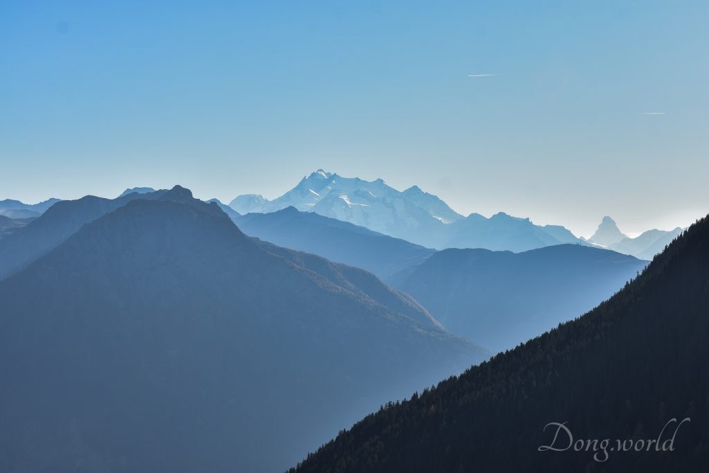
The extension of the natural World Heritage property of Jungfrau – Aletsch – Bietschhorn (first inscribed in 2001), expands the site to the east and west, bringing its surface area up to 82,400 ha., up from 53,900. The site provides an outstanding example of the formation of the High Alps, including the most glaciated part of the mountain range and the largest glacier in Eurasia. It features a wide diversity of ecosystems, including successional stages due particularly to the retreat of glaciers resulting from climate change. The site is of outstanding universal value both for its beauty and for the wealth of information it contains about the formation of mountains and glaciers, as well as ongoing climate change. It is also invaluable in terms of the ecological and biological processes it illustrates, notably through plant succession. Its impressive landscape has played an important role in European art, literature, mountaineering and alpine tourism.
少女峰–阿雷奇冰河–毕奇霍恩峰: 自然世界遗产少女峰–阿雷奇冰河–毕奇霍恩峰(最早于2001年被列入)从东部扩展到西部,面积从53 900公顷扩展到82 400公顷。该遗址为阿尔卑斯高山——包括山脉最受冰河作用的部分和欧亚大陆山脉最大的冰川——的形成提供了一个杰出的实例。它以生态系统多样性为特点,包括特别受气候变化冰川融化而形成的演替阶段。该遗址因景色秀美、而且包含山脉和冰川形成以及正在发生的气候变化方面的丰富知识而具有突出的全球价值。在它尤其通过植物演替所阐释的生态和生物过程方面,该遗址的价值无法衡量。其令人难忘的景观在欧洲艺术、文化、登山和阿尔卑斯山旅游中起着重要作用。
In general, this protected area is like a natural school, teaching all its admirers about biology, geology and ecology. From the glacial features to the formation of the high Alps, from the diversity of flora and fauna to the demonstration of global climate change, from the amazing mountain scenery to the developed tourism, Swiss Alps Jungfrau-Aletsch-Bietschhorn is undoubtedly an area that one should visit at least once in a life time.
Whether you are a geologist, a biologist or simply a traveller, you will be deeply attracted by this area, not only because of its beauty, but also because of the knowledge it possesses. Do you know what the classical glacial features are? Do you know how and when the high Alps were formed? Can you recognize the diverse flora and fauna here? All the puzzles in your mind related to glacier and the high Alps will be answered here.
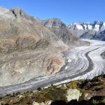
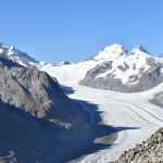
In fact, as early as 20 to 40 million years ago, the precesses of uplift and compression formed the Alps. During millions of years, Aletsch glacier has “designed and constructed” many geomorphological features such as U-shaped glacier valleys, cirques, horn peaks, valley glaciers and moraines. Another contribution that Aletsch glacier made is to the research of alpine and subalpine plant colonization and succession as well as to the research of global climate change. Because of the difficulty to access by the general public, a variety of ecosystems have evolved with little human intervention. A diversity of flora and fauna is represented in a range of habitats. With the retreating of the glacier, new substrates appear and the colonization of new plants also demonstrates an outstanding example of plant succession. Last but not least, the varying rates of the retreating of Aletsch glacier testify to not only to the history but also to the ongoing process of the global phenomenon – climate change.
If you have already read my previous three posts about appreciating, learning about and traveling in this region, you will probably find the above paragraphs familiar. If not, I strongly recommend you taking a look at them because in order to have a “complete” image of the Aletsch glacier, only looking at the it from the viewpoint close to Belalp is far from enough. The three viewpoints close to the mountain stations of Moosfluh (2333m), Bergstation Bettmerhorn (2647m) and Bergstation Eggishorn (2869m) will reveal to you the glacier from it’s near end to its origin – the Grosser Aletschfirn, Jungfraufirn, Ewigschneefäld and Grüneggfirn. Why do I now recommend you taking this hiking route from Belalp to Riederalp if you can already see the whole Aletsch glacier? Well, did you notice that I said “complete” with quotation marks? Did you notice that I said “near end”? Maybe I have slight “Obsessive compulsive disorder”, but from the Belalp viewpoint or the suspension bridge, you will be able to see how the ice-cold glacier water leaves the mouth of the great Aletsch glacier and how it roars through the Massa Gorge. For me, till that moment did I get a full (without quotation marks) picture of this magnificent Aletsch glacier. If I call those three viewpoints the best platforms to view the Aletsch glacier of today, then the hike from the viewpoint close to Belalp cable car station to Riederalp provides the best “platform” to “view” the history of it. Maybe you don’t understand what I mean now but after you finish reading the relevant two posts, you will most likely agree with me. In the next paragraph I’ll introduce to you how I am gonna organize the content of these two posts and I hope you will have a clear idea of its structure.
In this post, firstly, I’ll provide you in the first chapter with some facts or knowledge about the current Aletsch glacier (same as I’ve written in the posts about the three viewpoints within the Aletsch Arena). However, I regret to tell you that the current glacier is not the focus of these specific two posts. Instead, the history of it told by the traces left behind during its advance and retreat as well as the cultural activities held in this area is more emphasized here. If you are more interested in watching and appreciating the Aletsch glacier as it is now, please click on the links to the posts of viewpoints Moosfluh, Bettmerhorn and Eggishorn. In the second chapter, I’m gonna give you a brief introduction to this hiking route “Belalp – Reideralp” such as how long it is, how long it takes to finish it and what the highlights along the way are. In the third chapter, a detailed explanation, my own experiences as well as photos that I took during my visit will be included in each section, which is dedicated to each of the highlights. (Please excuse me for moving 60% of the third chapter, which was initially designed to be in this post, to the second post. This is because after I finished writing about this hiking experience I noticed that the word count exceeded 6800, which is bit too big for one post and readers usually get bored after reading so many words.) Now, let’s start by getting to know something about this titan who has been “living” longer than any other residents here in this region.
1. Facts about the Aletsch glacier
Please note that the facts about the current Aletsch glacier shown below are the same as I’ve written in my previous posts about the three viewpoints close to Moosfluh, Bettmerhorn and Eggishorn. If you have already read them you can jump directly to the second chapter.

- Surface: 81.7 km2
- Length: 22.6 km
- Depth: 900 m (the deepest or thickest part)
- Weight: 27 billion tons
- The glaciers of Aletsch, Jungfrau, Ewigschneefäld and Grünegg join together at the Konkordia Square and become the Great Aletsch Glacier.
- The glacier actually flows but is invisible to our eyes. At Konkordia Square the velocity is around 200 m/year while at the altitude of Bettmerhorn it reaches 80-90 m/year. The glacier doesn’t flow steadily and different parts also flow at different speeds. That’s how the glacier crevasses occur. Research shows that due to frictional resistance, the flow slows down on sides and underneath.
- On a hot summer day, 60 cubic meters of water can leaves the mouth of the glacier in one second and that’s 60 thousand liters of water per second! The glacier can diminish by 20 cm in thickness on a hot summer day and in one year, it can diminish by 12 meters. However, due to other factors, the actual number is smaller.
- If the whole glacier melts , the amount of water will be enough for each person in the world to have one liter per day for six years. The weight of the glacier is 27 billion tons, which is equal to the weight of 72.5 million Boeing-747 planes.
- In 10 years, 1 m of fresh snow is converted into 1 cm of glacial ice.
- Have you ever seen a glacier table before? It is formed by a large stone supported by a glacial column, the cooperation of the glacier and the sun.
- Have you ever wondered that in the world of glacial ice, are there living creatures? The answer is yes. The 1.5-2.5 mm long glacier fleas live on the glacier all year round and have a life span of around 3 years. They can survive up to -20 °C but can’t live when the temperature is higher than +10-12 °C.
If you are especially interested in the knowledge or facts about the Aletsch glacier, I strongly recommend you going to the second viewpoint close to Bettmerhorn because the info boards there together with the exhibition called “Faszination Aletschgletscher” will surely satisfy your curiosity. If you can’t wait to learn about it now you can also have a look at my post called “Swiss Alps Jungfrau-Aletsch-Bietschhorn (2/3) – Viewpoint Bettmerhorn“, which focuses on the second viewpoint with the info boards as well as the exhibition that I mentioned just before. Now let’s take a brief look at what kind of adventure lies ahead and some practical information such as cable car schedules and tickets.
2. Introduction to the hiking route (Belalp – Riederalp) and cable car info


The reason why I call it a hike to remember is not only that it’s been named the UNESCO Panorama Path but also that it gives you unforgettable experiences as well as surprises along the way. A long time ago it was possible to cross the Aletsch glacier to reach Riederalp from Belalp or the other way around. However, recently, the retreat of the glacier has made this impossible. Thanks to the cooperation of Pro Natura, WWF and UNESCO World Heritage Site Swiss Alps Jungfrau-Aletsch, a suspension bridge was constructed and opened in 2008 to restore the link between the two old villages. The suggested route (or the route that I took) was from Brig (bus) -> Blatten (gondola car) -> Belalp (hiking) -> Hotel Belalp (hiking) -> Aletschji (hiking) -> Suspension Bridge or Hängebrücke (hiking) -> the Green Lake or Grünsee (hiking) -> Aletsch forest (hiking) -> Riederfurka and Villa Cassel (hiking) -> Riederalp (gondola car) -> Mörel (train) -> Brig. Seems like a long hiking route doesn’t it? Well, this is the longest hiking I’ve ever done and now I’ll show you some basic statistics about it:
- Total length: 14 km
- Time required: 5 h (plus some resting time and picnic time it took me around 7 hours)
- Maximum altitude: 2138 m
- highlights: Aletschbord viewpoint, Hotel Belalp, the “färricha” and “Zickzackweg”, Aletschji, the suspension bridge (Hängebrücke), Grünsee (the Green Lake), Aletsch forest and Pro Nature Center Aletsch (Villa Cassel) (Please note that the first two highlights will be explained in detail here in this post while the rest will be explained in the second post about this hike.)
I have to say that this path is indeed rich in culture and history and if you are fit, I strongly recommend you experiencing it. In general it is not difficult to walk on but there are some sections that can be a bit steep and slippery. That’s why I suggest you wear comfortable hiking shoes. I went there on a sunny day in autumn and it was rather warm because of the sunlight and all the exercises so if you are going at around the same period of time in the year as I did I recommend you wearing thin hiking along-sleeve shirts plus a light thermal jacket. In this case when you are in the shadow you can put the jacket on and when you are in the sunshine you can take it off and put it in your backpack. The other suggestion is that you should take enough water and food (energy snacks as well) with you because trust me, 5 h hiking down and up the mountains can burn quite some calories and don’t expect there being any restaurants or shops between Hotel Belalp and Riederfurka.
According to my research, it’s possible to either hike from Belalp to Riederalp or the other way around and you can buy tickets either at Blatten cable car station (starting from Belalp) or Mörel cable car station (starting from Riederalp) or even from a member of the MGBahn train crew. If you wanna start from Belalp like I did, you need to take a cable car from Blatten to Belalp first. Please
- click here to know more about the schedule and timetables of the cable cars (please note that there is a difference in the schedule and timetables of the cable cars in summer season, winter season and in-between seasons)
- and click here to know more about the ticket prices. (For example, Blatten – Belalp and Riederalp – Mörel, or reverse: CHF 21.40 (adults) and CHF 10.70 (Children (6-16 years old), Half-Price Card, GA Travelcard, FVP, Swiss Card/Pass and dogs.)
The information provided on the official website is mainly in German so if you don’t understand it or still have other questions, please don’t hesitate to contact me or click here to contact Blatten-Belalp Tourism Office directly.
If you decide to start your hike from Riederalp, you need to take a cable car from Mörel to Riederalp first and as for the timetables and ticket prices for this direction please click on the links respectively.
In the next chapter and in the following second post I’ll explain to you in detail why certain places or constructions are highlighted and why this path has been named the UNESCO Panorama Path. Are you ready? Now get dressed properly and get your backpack packed, let’s start our adventure!
3. The UNESCO Panorama Path and its highlights


As I mentioned before, this hiking path provides a perfect opportunity to explore, discover, understand and experience the local history, culture and tradition as well as the past of and the ecosystem around the great Aletsch glacier (particularly the Alestch forest). I suggest that when you’re at the cable car terminals, take some info brochures such as “World of glaciers”, “Ice streams in the Aletsch region”, “Naters, and its mountain, Birgisch, and Mund, the village of Saffron”, “Suonen are…”, which belong to parts of a series, explaining and emphasizing on the vital role that this site “Swiss Alps Jungfrau-Aletsch” plays in raising the awareness of our common heritage. With these information, each path, each stone, each house, each chapel, each village, each tree, each lake, each mountain and each piece of glacier ice becomes meaningful. My explanations below and in the second post of the highlights are also gonna be partially based on what I read from them and other books and partially on my own experiences and thoughts. I hope that by the time you take this hiking route, you will recognize and appreciate the values of this path and its surroundings. (Please note that the order of how I’m gonna introduce to you the highlights is in general in accordance with the order of the sites that I visited along my way. However, certain sections might overlap in the aspect of geological areas but not of the information or knowledge. For example, the Aletschji mountain pastures will be mentioned not only when introducing the history or tradition of local farming but also when explaining the history of the Aletsch glacier.)
3.1 The Belalp Bahnen cable car


Besides the beautiful views that you can see from the cable car, do you know what else is special about it? It’s the luck that it has been spared the fate of being taken out of service. The first cable car that came into use in the Upper Valais was built in 1946 from Turtig to Eischoll. Later on, the cable cars were installed in Mund, Birgisch and Blatten in 1951, 1953 and 1954 respectively. However, with the increasing need of transporting passengers as well as goods, the roads were constructed and the cables cars in Mund and Birgisch were taken out of service. Fortunately, the cable cars from Blatten to Belalp “survived” and in 1973, the two-person cabins were updated and exchanged with a much bigger gondola which can transport up to 80 people at one time, followed by a second one in 1979. In 2011, this specific cableway carried more than 400 thousand passengers.
3.2 A walk to the viewpoint Aletschbord


Once getting off the cable car, I was indeed shocked by the amazing scenery, the mountains, the sunshine, the chalets, and in particular the colors of the vegetation. It’s really hard to simply describe them. Some are red but red in different ways. Some are yellow and green but also to different degrees. As you can see from the pictures above, the colors are beyond definition because the power of nature is superior to any language of mankind. This will be the beginning and also the easiest section of your hiking path so just enjoy the view, wander around and relax.
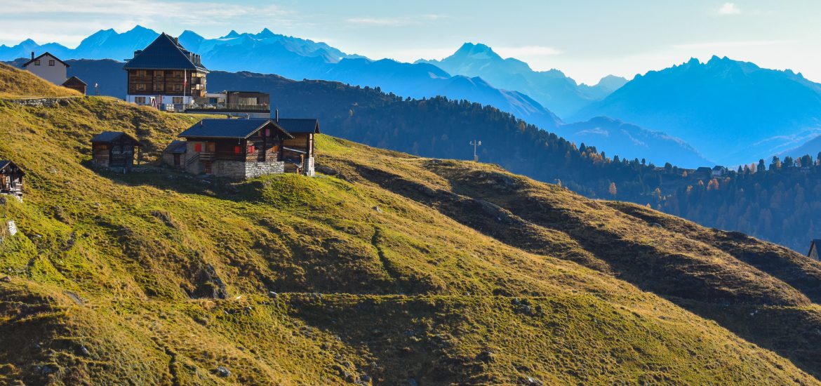
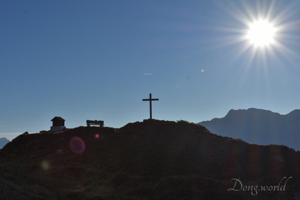
3.3 Hotel Belalp and the Anglican Chapel (viewpoint Aletschbord)


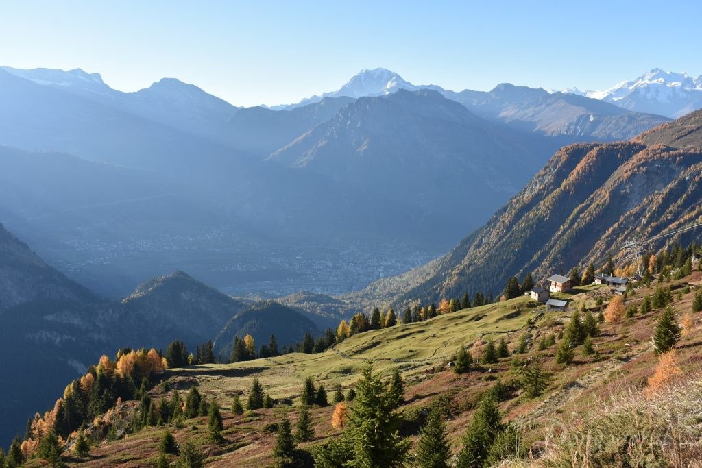
On your way to the viewpoint Aletschbord, you should be able to see a beautiful chalet with a terrace standing elegantly among the mountains (as you can see from the second picture). That is the famous Hotel Belalp, built by Leopold Bürcher between 1856 and 1857. By that time, he already saw the potential that Belpalp especially the Aletschbord possessed for attracting tourists because of it unique location with view of the Valais Alps and over the Aletsch glacier. In 1870, the co- and later sole owner of this hotel, Gervas Klingele built the stone extension. At that time, this hotel was much loved either in winter or in summer by numerous alpinists, mountaineers, hikers or simple travellers as the starting point of their adventures. The first that came here were the rich and famous, for example, the most renowned among them are Henri Dunant, Swiss businessman and social activist, the founder of the Red Cross, and the first recipient of the Nobel Peace Prize as well as H. H. Asquith, Prime Minister of the United Kingdom from 1908 to 1916. The Klingele family ran the hotel for 3 generations and in 1968, it was handed over to the Jaeger-Eggel family. Since 1993, this hotel has been the property of the Naters municipality. As you look around, I believe it won’t be difficult to notice a chapel against the background of some nicely shaped mountains (as shown in the third picture). That’s an Anglican chapel built between 1883 and 1884 for the purpose of meeting the needs of the British clientele. Standing there for more than a decade already, it has been witnessing the development of winter sports, all-year-round tourism as well as the “activities” of the great Aletsch glacier.
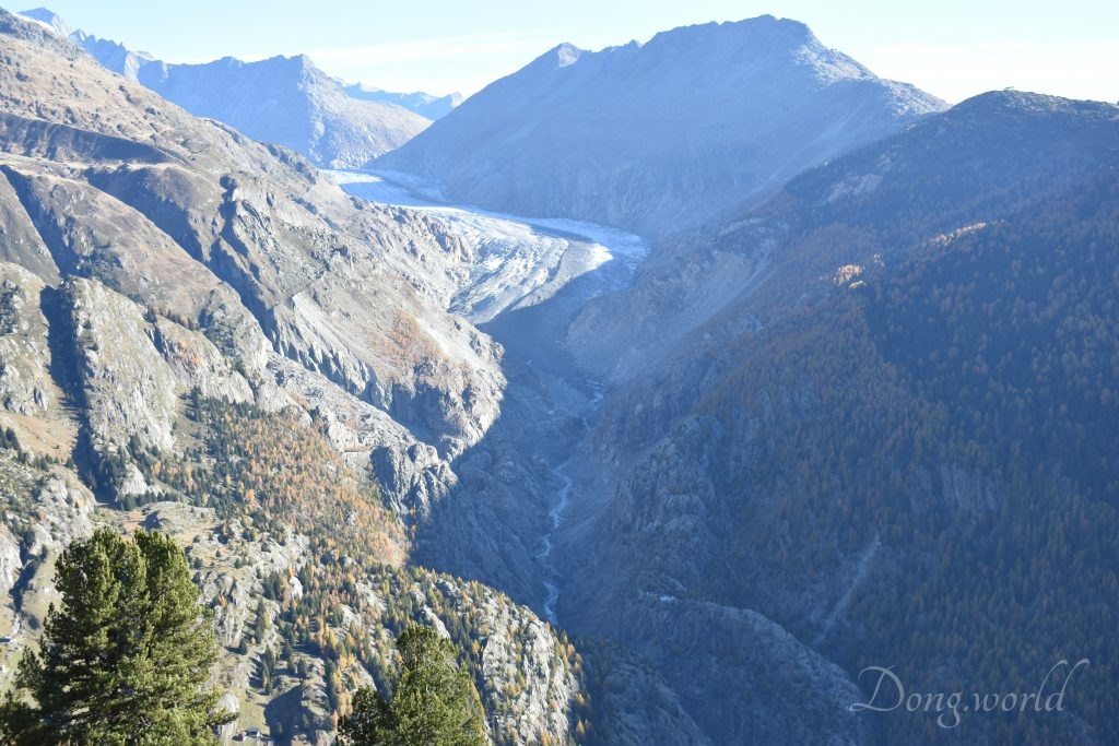
While you are admiring the history and fame of Hotel Balalp, don’t forget about the unique location that brought all the visitors here. Without the special Aletschbord viewpoint, Hotel Belalp would have just been an ordinary hotel like many others. Once you are here, you will be able to see most of the Valais Alps as well as the tail of the great Aletsch glacier. As I mentioned above, even though the viewpoints Moosfluh, Bettmerhorn and Eggishorn provide you with much better views of the head and main body of this giant, they can’t reveal the tail of it. From here you will see how the great Aletsch glacier gets narrower and narrower and when you are down in the valley, you will see how it turns into a stream that fills the Stausee Lake. If you are a photographer I suggest you arrive at this viewpoint at noon or in the early afternoon because during this period of time, the sunlight will be shed on the glacier and even to the deep valley that the glacier stream flows through. If you arrive too early in the morning or too late in the afternoon, half of the valley will be bright while the other half will be in the shadow, not a desired situation for photo shooting I guess. However, do keep in mind that the hiking takes around 5 hours and if you start from here (Aletschbord) at 13:00, you will be arriving at Riederalp at 18:00. Therefore, a good photo opportunity or a relaxing hiking experience without hurrying up, it’s totally your choice.
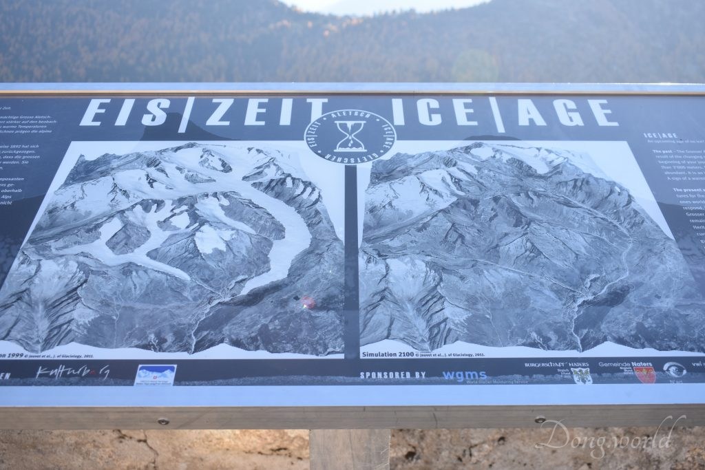
You will also see an info board here showing you how the glacier looked like in 1999 and how it will look like in 2100 based on estimation and prediction. Under the current situation of global climate change or to be more precise, global warming, this billboard focuses on the topic of “an upcoming age of no ice”. It mainly describes and explains the past, present and future of the glacier, aiming at raising people’s awareness of climate changes and the urgent need to protect our environment.
Now continuing in the second post, let’s start descending from Aletschbord to the suspension bridge and along the way you will learn so much about the tradition and life of the local farmers, also called the nomads.
(As mentioned above, the second post will continue to focus on explaining in detail the highlights including the the “färricha” and “Zickzackweg“, Aletschji, the suspension bridge (Hängebrücke), Aletsch forest, Grünsee (the Green Lake) and Pro Nature Center Aletsch (Villa Cassel).